IMAGES TAKEN NEAR TO
Headway Road, WOLVERHAMPTON, WV10 6PZ
Introduction
This page details the photographs taken nearby to Headway Road, WV10 6PZ by members of the Geograph project.
The Geograph project started in 2005 with the aim of publishing, organising and preserving representative images for every square kilometre of Great Britain, Ireland and the Isle of Man.

There are currently over 7.5m images from over14,400 individuals and you can help contribute to the project by visiting https://www.geograph.org.uk
Image Map
Images are licensed for reuse under creativecommons.org/licenses/by-sa/2.0
Notes
- Clicking on the map will re-center to the selected point.
- The higher the marker number, the further away the image location is from the centre of the postcode.
Image Listing (45 Images Found)
Images are licensed for reuse under creativecommons.org/licenses/by-sa/2.0
Image
Details
Distance
1
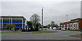
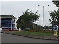
Vine Island on the A449 in Fordhouses, Wolverhampton
Looking north on a dull autumn morning along the Stafford Road, towards Penkridge and Stafford.
The blue Brammer UK distribution Centre is on the left.
Image: © Roger Kidd
Taken: 30 Nov 2022
0.04 miles
2
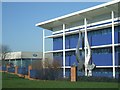
Modern factory
Brammer factory making specialist products for the aerospace and motor industries.
Image: © John M
Taken: 3 Feb 2007
0.05 miles
4
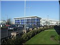
Modern industrial units
The Stafford Road in Fordhouses has a number of specialist firms associated with the aerospace and motor industries. These are new premises for BSL Brammer.
Image: © John M
Taken: 3 Feb 2007
0.05 miles
5
Bee Lane roundabout
Among the numerous roundabouts on the A449, this stands out. The design is oval, but with the long sides aligned for the minor road. Traffic on the A449 faces very tight turns around the ends of the roundabout to travel straight ahead.
Image: © J Whatley
Taken: 6 Sep 2010
0.06 miles
6
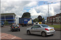
Roundabout on Stafford Road, Fordhouses
Image: © Mark Anderson
Taken: 18 Jun 2012
0.07 miles
7
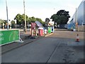
Petrol station on Stafford Road, Fordhouses
Image: © David Howard
Taken: 3 Jun 2018
0.07 miles
8
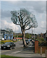
All wrapped up like a Christmas Tree
It was suggested that the reason for doing this is to stop birds nesting in trees which are about to be felled or pollarded.
Image: © Keith Edkins
Taken: 14 Apr 2012
0.07 miles
9
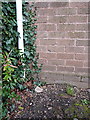
OS benchmark - Fordhouses, 160 Wobaston Road
An OS cutmark on the north wall of a house on Wobaston Road; originally levelled at 113.501m above Ordnance Datum Newlyn.
Image: © Richard Law
Taken: 1 Mar 2016
0.07 miles
10
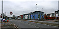
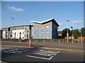
Stafford Road housing in Fordhouses, Wolverhampton
Stafford Road is the A449, leading north to Penkridge and Stafford. In this view the road is approaching the Vine Island (90 metres).
Modern apartments are on the right past Bee Lane.
Image: © Roger Kidd
Taken: 30 Nov 2022
0.08 miles