IMAGES TAKEN NEAR TO
Bee Lane, WOLVERHAMPTON, WV10 6LE
Introduction
This page details the photographs taken nearby to Bee Lane, WV10 6LE by members of the Geograph project.
The Geograph project started in 2005 with the aim of publishing, organising and preserving representative images for every square kilometre of Great Britain, Ireland and the Isle of Man.

There are currently over 7.5m images from over14,400 individuals and you can help contribute to the project by visiting https://www.geograph.org.uk
Image Map
Images are licensed for reuse under creativecommons.org/licenses/by-sa/2.0
Notes
- Clicking on the map will re-center to the selected point.
- The higher the marker number, the further away the image location is from the centre of the postcode.
Image Listing (50 Images Found)
Images are licensed for reuse under creativecommons.org/licenses/by-sa/2.0
Image
Details
Distance
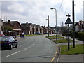
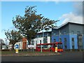
2
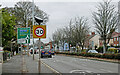
Housing in Fordhouses, Wolverhampton
Looking across Stafford Road, south-east towards Bee Lane and Bushbury.
Image: © Roger Kidd
Taken: 30 Nov 2022
0.04 miles
5
Stafford Road approaching the Vine Island in Wolverhampton
Stafford Road is the A449, leading north to Penkridge and Stafford. In this view the road is approaching the Vine Island (190 metres).
Image: © Roger Kidd
Taken: 30 Nov 2022
0.07 miles
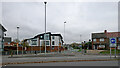
6
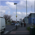
Lamp-belisha
A combination of signal and illumination on a single pole, which I haven't seen elsewhere.
Image: © Keith Edkins
Taken: 17 Apr 2008
0.07 miles
7
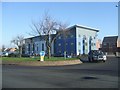
Apartment development on Vine Island
The modern style of this development blends in with the modern factory units opposite. The Vine Inn formerly occupied this site and the developer has picked up the vine motif in the perimeter fencing (Image).
Image: © John M
Taken: 3 Feb 2007
0.08 miles
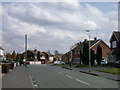
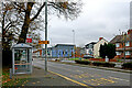
8
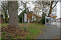
Housing and bus stop in Stafford Road, Wolverhampton
Stafford Road is the A449, leading north to Penkridge and Stafford. In this view the road is approaching the Vine Island (125 metres). Fordhouses Methodist Church is off to the left (access from Winchester Road).
Currently the 878 bus route goes to Stafford twice a day (11:11 and 12:11), via several villages. A few other buses just serve some of the villages. Route 877 goes to Stafford twice a day (10:11 and 13:11) via a different set of villages.
Image: © Roger Kidd
Taken: 30 Nov 2022
0.08 miles
9
Vine Island (traffic island) and modern apartments
Image: © David Smith
Taken: 19 Oct 2011
0.08 miles
10
Stafford Road bus stop near Fordhouses in Wolverhampton
Stafford Road is the A449, leading north to Penkridge and Stafford. In this view the road is approaching the Vine Island (125 metres). Fordhouses Methodist Church is off to the left (access from Winchester Road).
Currently the 878 bus route goes to Stafford twice a day (11:11 and 12:11), via several villages. A few other buses just serve some of the villages. Route 877 goes to Stafford twice a day (10:11 and 13:11) via a different set of villages.
Image: © Roger Kidd
Taken: 30 Nov 2022
0.08 miles