IMAGES TAKEN NEAR TO
The Downs, WOLVERHAMPTON, WV10 6JA
Introduction
This page details the photographs taken nearby to The Downs, WV10 6JA by members of the Geograph project.
The Geograph project started in 2005 with the aim of publishing, organising and preserving representative images for every square kilometre of Great Britain, Ireland and the Isle of Man.

There are currently over 7.5m images from over14,400 individuals and you can help contribute to the project by visiting https://www.geograph.org.uk
Image Map
Images are licensed for reuse under creativecommons.org/licenses/by-sa/2.0
Notes
- Clicking on the map will re-center to the selected point.
- The higher the marker number, the further away the image location is from the centre of the postcode.
Image Listing (173 Images Found)
Images are licensed for reuse under creativecommons.org/licenses/by-sa/2.0
Image
Details
Distance
1
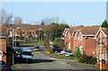
Recent Housing, Wolverhampton
This is The Downs, a recent development in close proximity to the railway and the canal, the A449, and Oxley golf course.
Image: © Roger D Kidd
Taken: 17 Feb 2008
0.03 miles
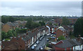
2

The Downs, Oxley
Seen from the towpath of the Birmingham Main Line Canal.
Image: © Richard Vince
Taken: 8 Dec 2018
0.04 miles
4
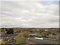
Cityscape, houses on Jones Road, Wolverhampton
Image: © Roy Hughes
Taken: 13 Nov 2021
0.06 miles
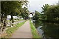
6
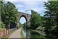
Birmingham Canal Navigations at Oxley Viaduct in Wolverhampton
Looking east-south-east from near Lock No 17, towards Wolverhampton city centre and Birmingham. The Grade II listed Oxley Viaduct (1847-1849) carries the railway line to Telford and Shrewsbury.
Sustrans National Route 81 (Aberystwyth to Wolverhampton) for cyclists passes along the towpath here, so non-waterways funding is available to help maintain the surface.
Image: © Roger Kidd
Taken: 20 Jun 2022
0.06 miles
7
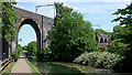
Oxley Viaduct in Wolverhampton
This is the Birmingham Canal Navigations, looking east-south-east towards Wolverhampton city centre and Birmingham. The Grade II listed Oxley Viaduct (1847-1849) carries the railway line to Telford and Shrewsbury.
Beyond the viaduct, is Lock No 16 in the Wolverhampton flight of 21.
Sustrans National Route 81 (Aberystwyth to Wolverhampton) for cyclists passes along the towpath here, so non-waterways funding is available to help maintain the surface.
Image: © Roger Kidd
Taken: 20 Jun 2022
0.06 miles
8
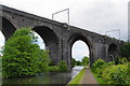
Birmingham Canal Navigations at Oxley Viaduct in Wolverhampton
Looking east-south-east towards Wolverhampton city centre and Birmingham. The Grade II listed Oxley Viaduct (1847-1849) carries the railway line to Telford and Shrewsbury.
Beyond the viaduct, is Lock No 16 in the Wolverhampton flight of 21.
Sustrans National Route 81 (Aberystwyth to Wolverhampton) for cyclists passes along the towpath here, so non-waterways funding is available to help maintain the surface.
Image: © Roger Kidd
Taken: 20 Jun 2022
0.06 miles
9

South Street, Wolverhampton
As seen from the Birmingham Canal.
Image: © Bill Boaden
Taken: 22 May 2011
0.06 miles
10
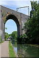
The Dunstall Viaduct crossing the Birmingham Canal
Image: © Bill Boaden
Taken: 22 May 2011
0.06 miles