IMAGES TAKEN NEAR TO
Stafford Road, WOLVERHAMPTON, WV10 6HZ
Introduction
This page details the photographs taken nearby to Stafford Road, WV10 6HZ by members of the Geograph project.
The Geograph project started in 2005 with the aim of publishing, organising and preserving representative images for every square kilometre of Great Britain, Ireland and the Isle of Man.

There are currently over 7.5m images from over14,400 individuals and you can help contribute to the project by visiting https://www.geograph.org.uk
Image Map
Images are licensed for reuse under creativecommons.org/licenses/by-sa/2.0
Notes
- Clicking on the map will re-center to the selected point.
- The higher the marker number, the further away the image location is from the centre of the postcode.
Image Listing (220 Images Found)
Images are licensed for reuse under creativecommons.org/licenses/by-sa/2.0
Image
Details
Distance
1
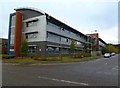
Wolverhampton Science Park
One of several buildings on the campus off Stafford Road; this is at the corner of Coxwell Avenue and Mammoth Drive. http://www.wolverhamptonsp.co.uk/
Image: © Mike Faherty
Taken: 12 Oct 2011
0.00 miles
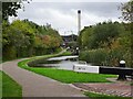
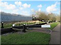
2
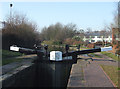
Wolverhampton Locks No 14
Birmingham Canal Navigations. The flight of twenty-one locks completed James Brindley's Canal link from Birmingham to Aldersley Junction (joining the Staffordshire and Worcestershire Canal) which opened its full 22.5 mile (36km) by 1772. The flight alters the water level by 121 feet (37 metres) over two miles.
Image: © Roger D Kidd
Taken: 17 Feb 2008
0.01 miles
3
Wolverhampton Locks No 14
The flight of twenty-one locks completed James Brindley's Canal link from Birmingham to Aldersley Junction (joining the Staffordshire and Worcestershire Canal) which opened its full 22.5 mile (36km) by 1772. The flight alters the water level by 132 feet (40 metres) over two miles.
Image: © Roger D Kidd
Taken: 17 Feb 2008
0.01 miles
4
Birmingham Canal
Lock number 14 on the Birmingham canal.
Image: © Roger Dean
Taken: 27 Dec 2006
0.01 miles
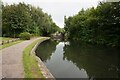
5
Lock 14 View
The view up the Birmingham Canal at Dunstall near the Wolverhampton Science Park off the Stafford Road.
Image: © Gordon Griffiths
Taken: 27 Oct 2021
0.02 miles
6
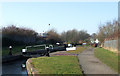
Wolverhampton "21" lock flight drained.
This was taken in the early 1990s, when the canal was drained and a number of the lock gates replaced. I'm guessing 1993, but to be honest I could be a year out either way. If anyone knows better, do let me know.
Later on in life I bought a 52' narrowboat to live on. One of my more memorable moments was singlehanding it down all 21 locks in this flight in about two hours!
Image: © John Winder
Taken: Unknown
0.02 miles
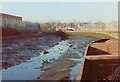
7

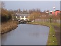
View towards the Incinerator
The view from lock 14 on the Birmingham Canal at Dunstall near the Wolverhampton Science Park towards the Civic Incinerator in Wolverhampton.
Image: © Gordon Griffiths
Taken: 3 Jun 2024
0.02 miles
8
Old Main Line Canal towards Wolverhampton #14 Lock
Image: © Ian S
Taken: 4 Sep 2021
0.02 miles
9
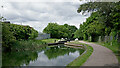
Canal at Wolverhampton Locks No 14
There are 21 locks (originally 20) in the Wolverhampton flight, lowering the Birmingham Canal Navigations Main Line (Wolverhampton Level) by 132 feet (40 metres) to the Staffordshire and Worcestershire Canal at Aldersley Junction, in about one and three quarter miles.
Sustrans National Route 81 for cyclists passes along the towpath here. This is the way to Telford, Shrewsbury, Welshpool, Newtown and Aberystwyth avoiding most heavy traffic. Walkers should be aware that some cyclists are fit and fast, almost silent and don't always use their bells (if they even have one)!
Image: © Roger Kidd
Taken: 28 May 2022
0.02 miles
10
Birmingham Canal Mainline. Wolverhampton - Lock No. 14
Canal lock. c1770. By Brindley, Whitworth and Simcock, engineers. Brick with some stone coping. Double lower and single upper gates. The lock is one of a flight of 21 on the Birmingham Canal, Wolverhampton level. Listed Grade II.
Image: © Chris Allen
Taken: 3 Mar 2024
0.02 miles