IMAGES TAKEN NEAR TO
Mallory Road, WOLVERHAMPTON, WV10 6GX
Introduction
This page details the photographs taken nearby to Mallory Road, WV10 6GX by members of the Geograph project.
The Geograph project started in 2005 with the aim of publishing, organising and preserving representative images for every square kilometre of Great Britain, Ireland and the Isle of Man.

There are currently over 7.5m images from over14,400 individuals and you can help contribute to the project by visiting https://www.geograph.org.uk
Image Map
Images are licensed for reuse under creativecommons.org/licenses/by-sa/2.0
Notes
- Clicking on the map will re-center to the selected point.
- The higher the marker number, the further away the image location is from the centre of the postcode.
Image Listing (43 Images Found)
Images are licensed for reuse under creativecommons.org/licenses/by-sa/2.0
Image
Details
Distance
1
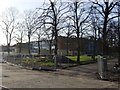
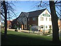
Rear of former offices at the Goodyear site
The former Goodyear European HQ buildings were occupied by Promise Finance until the firm passed into receivership in 2008. The building will be demolished to make way for a Hungry Horse pub and restaurant. Following recent changes in government legislation the developer's Greene King will not be required to provide £25000 for public art on the site. It was said that this would render the scheme non viable.
Image: © John M
Taken: 3 Dec 2011
0.08 miles
2
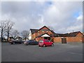
The Gatehouse
The view of the Pub by the Stafford Road on the former Goodyear's Tyre Factory site in Oxley, Wolverhampton.
Image: © Gordon Griffiths
Taken: 28 Jan 2020
0.09 miles
3
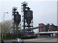
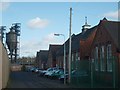
Storage silos and conveyors at Goodyear's factory
These are a landmark on the local skyline. How long they will remain is uncertain with tyre manufacturing shifting to lower cost factories in Eastern Europe and the Far East. Large parts of the Goodyear site have been sold off for redevelopment. Goodyear was one of the major employers in Wolverhampton for many years.
Image: © John M
Taken: 21 Apr 2007
0.09 miles
4
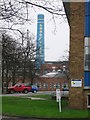
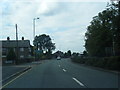
Goodyear Factory from the A449
This distinctive chimney can be seen from all round the local area. The factory has undergone a lot of change over the last few years.
Image: © Angella Streluk
Taken: 22 Apr 2006
0.10 miles
5
The Gatehouse PH
New public house at the entrance to the housing development on the former Goodyear factory site.
Image: © John M
Taken: 11 Nov 2012
0.10 miles
7
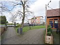
Oxley Primary School
The School in Ripon Road in the shadow of Goodyear's Tyre Factory has a smell of rubber hanging over it.
Image: © Gordon Griffiths
Taken: 6 Feb 2008
0.11 miles
8
Gatehouse Horse
The view of the Pub by the Stafford Road on the former Goodyear's Tyre Factory site in Oxley, Wolverhampton.
Image: © Gordon Griffiths
Taken: 28 Jan 2020
0.11 miles
9
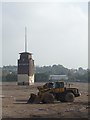
Clocktower on the Goodyear site
Two years on from the chimney demolition Image there is no sign of the housing and retail development. The clock tower is built on a former water tank structure possibly dating from the 1920s prior to Goodyear taking over and developing the site.
Image: © John M
Taken: 10 Oct 2010
0.12 miles
10
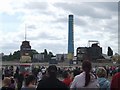
Last moments of a local landmark
The Goodyear chimney has stood here since the 1920s. Tyre manufacturing has moved to cheaper locations leaving only a small operation on a corner of the site. The remainder is to be redeveloped for housing and retail use.
A large crowd has gathered on a Sunday morning to see the demolition of the chimney, the last building on the site.
Image: © John M
Taken: 29 Jun 2008
0.12 miles