IMAGES TAKEN NEAR TO
Southbourne Road, WOLVERHAMPTON, WV10 6ET
Introduction
This page details the photographs taken nearby to Southbourne Road, WV10 6ET by members of the Geograph project.
The Geograph project started in 2005 with the aim of publishing, organising and preserving representative images for every square kilometre of Great Britain, Ireland and the Isle of Man.

There are currently over 7.5m images from over14,400 individuals and you can help contribute to the project by visiting https://www.geograph.org.uk
Image Map
Images are licensed for reuse under creativecommons.org/licenses/by-sa/2.0
Notes
- Clicking on the map will re-center to the selected point.
- The higher the marker number, the further away the image location is from the centre of the postcode.
Image Listing (52 Images Found)
Images are licensed for reuse under creativecommons.org/licenses/by-sa/2.0
Image
Details
Distance
1
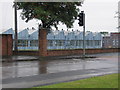
Factory in Fordhouses
This is typical of the type of factory buildings on the outskirts of Wolverhampton.
Image: © Angella Streluk
Taken: 30 Jul 2005
0.06 miles
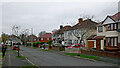
2

Fordhouses Baptist Church
The view from Harroway Road.
Image: © Gordon Griffiths
Taken: 1 Jul 2009
0.11 miles
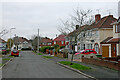
3
Newbury Road near Fordhouses in Wolverhampton
Looking north-west towards Winchester Road from the junction with the A449 Stafford Road.
Image: © Roger Kidd
Taken: 30 Nov 2022
0.13 miles
4
Newbury Road near Fordhouses in Wolverhampton
Looking north-west towards Winchester Road from the junction with the A449 Stafford Road.
Image: © Roger Kidd
Taken: 30 Nov 2022
0.13 miles
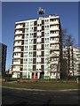
5

Council Housing - Patshull Court
The 1964 tower block on the Chetton Green Estate was refurbished in 2009. It is linked with Harrowby Court to provide sheltered housing for over 60s.
Image: © John M
Taken: 9 Jan 2011
0.14 miles
6
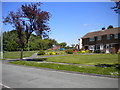
North end of Brinsford Road, Wobaston
At its north end, Brinsford Road (foreground) widens out to provide a pleasant patch of grass at its junction with Patshull Avenue.
Image: © Richard Vince
Taken: 4 Jun 2013
0.14 miles
7
Council Housing - Harrowby Court
The three tower blocks on the Chetton Green Estate were built in 1964. Renovated in 2009 and operated by Wolverhampton Homes to provide sheltered housing for the over 60s.
The estate received a Civic Trust Award in 1966.
http://www.localhistory.scit.wlv.ac.uk/interesting/civic/chettonbosc.htm
Image: © John M
Taken: 9 Jan 2011
0.14 miles
8
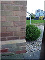
OS benchmark - Fordhouses, 42 Patshull Avenue
An OS cutmark on the side wall of no 42 Patshull Ave; originally levelled at 112.157m above Ordnance Datum Newlyn.
Image: © Richard Law
Taken: 1 Mar 2016
0.15 miles
9
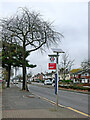
Stafford Road bus stop near Bushbury in Wolverhampton
Stafford Road is the A449, leading north to Penkridge and Stafford.
Currently the 878 bus route goes to Stafford twice a day (11:11 and 12:11), via several villages. A few other buses just serve some of the villages. Route 877 goes to Stafford twice a day (10:11 and 13:11) via a different set of villages.
Image: © Roger Kidd
Taken: 30 Nov 2022
0.15 miles
10
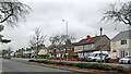
Stafford Road near Bushbury in Wolverhampton
Stafford Road is the A449, leading north to Penkridge and Stafford.
Image: © Roger Kidd
Taken: 30 Nov 2022
0.15 miles