IMAGES TAKEN NEAR TO
Winchester Road, WOLVERHAMPTON, WV10 6EH
Introduction
This page details the photographs taken nearby to Winchester Road, WV10 6EH by members of the Geograph project.
The Geograph project started in 2005 with the aim of publishing, organising and preserving representative images for every square kilometre of Great Britain, Ireland and the Isle of Man.

There are currently over 7.5m images from over14,400 individuals and you can help contribute to the project by visiting https://www.geograph.org.uk
Image Map
Images are licensed for reuse under creativecommons.org/licenses/by-sa/2.0
Notes
- Clicking on the map will re-center to the selected point.
- The higher the marker number, the further away the image location is from the centre of the postcode.
Image Listing (61 Images Found)
Images are licensed for reuse under creativecommons.org/licenses/by-sa/2.0
Image
Details
Distance
1

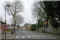
Winchester Road View
The view up Marsh Lane, Fordhouses.
Image: © Gordon Griffiths
Taken: 1 Jul 2009
0.05 miles
2
Marsh Lane near Oxley in Wolverhampton
Looking west-north-west from the junction with the A449 Stafford Road.
Image: © Roger Kidd
Taken: 30 Nov 2022
0.08 miles
3
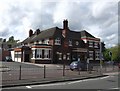
The 'Three Tuns'
A decline in trade has seen a number of suburban pubs either converted to restaurants or demolished and the sites re-used. This one on the Stafford Road is now a very large Chinese restaurant.
Image: © John M
Taken: 7 May 2007
0.10 miles
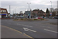
4
Stafford Road near Bushbury in Wolverhampton
This shows the A449 Stafford Road near the Three Tuns roundabout, looking north towards Penkridge and Stafford.
Image: © Roger Kidd
Taken: 26 Nov 2020
0.10 miles
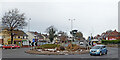
5
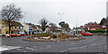
Three Tuns roundabout in Wolverhampton
Looking north, this is the Three Tuns Roundabout on the A449 Stafford Road two and a half miles (4km) north of the city centre. Off to the right is Three Tuns Lane, leading towards Bushbury and Old Fallings. Off to the left is Marsh Lane, leading to extensive housing estates. Nearby, and behind the camera, is a large red-brick building (now a Chinese restaurant) which used to be the Three Tuns public house.
Image: © Roger Kidd
Taken: 29 Nov 2021
0.10 miles
6
Stafford Road roundabout near Oxley, Wolverhampton
Looking north, this is the Three Tuns Roundabout on the A449 Stafford Road two and a half miles (4km) north of the city centre. Off to the right is Three Tuns Lane, leading towards Bushbury and Old Fallings. Off to the left is Marsh Lane, leading to extensive housing estates. Nearby, and behind the camera, is a large red-brick building (now a Chinese restaurant) which used to be the Three Tuns public house.
Image: © Roger Kidd
Taken: 29 Nov 2021
0.10 miles
7
Stafford Road near Bushbury in Wolverhampton
This shows the A449 Stafford Road by Three Tuns roundabout, looking north towards Penkridge and Stafford.
Image: © Roger Kidd
Taken: 26 Nov 2020
0.10 miles
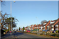
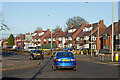
9
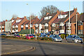
Housing by Stafford Road near Bushbury, Wolverhampton
Stafford Road is the A449. The housing here is north of the Three Tuns roundabout.
Image: © Roger Kidd
Taken: 26 Nov 2020
0.11 miles
10
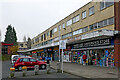
Marsh Lane Parade in Wolverhampton
This is by the A449 Stafford Road near Oxley. Marsh Lane Parade shops and the accommodation above are looking very dilapidated externally, as is the adjacent Ming Moon Chinese Restaurant (formerly Three Tuns public house). One wonders whether this run-down site is in line for demolition and redevelopment.
Image: © Roger Kidd
Taken: 30 Nov 2022
0.12 miles