IMAGES TAKEN NEAR TO
Kipling Road, WOLVERHAMPTON, WV10 6BN
Introduction
This page details the photographs taken nearby to Kipling Road, WV10 6BN by members of the Geograph project.
The Geograph project started in 2005 with the aim of publishing, organising and preserving representative images for every square kilometre of Great Britain, Ireland and the Isle of Man.

There are currently over 7.5m images from over14,400 individuals and you can help contribute to the project by visiting https://www.geograph.org.uk
Image Map
Images are licensed for reuse under creativecommons.org/licenses/by-sa/2.0
Notes
- Clicking on the map will re-center to the selected point.
- The higher the marker number, the further away the image location is from the centre of the postcode.
Image Listing (83 Images Found)
Images are licensed for reuse under creativecommons.org/licenses/by-sa/2.0
Image
Details
Distance
1
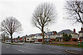
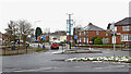
Houses in Three Tuns Lane near Bushbury in Wolverhampton
Looking north-west across the dual carriageway from near the junction with Crathorne Avenue. Three Tuns Lane leads towards the A449 Stafford Road, about three hundred metres away.
Image: © Roger Kidd
Taken: 29 Nov 2021
0.07 miles
2
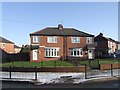
Council Housing - Shelley Road
The Three Tuns Estate was built in 1937.
Image: © John M
Taken: 25 Dec 2009
0.08 miles
3
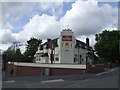
The Woodbine
The large retaining wall in front of the pub was built to allow Elston Hall Road to be lowered and re-aligned to pass under the new railway bridge.
Image: © John M
Taken: 7 May 2007
0.08 miles
4

Three Tuns Lane near Elston Hall in Wolverhampton
Looking north-west towards the A449 Stafford Road. Ahead, Crathorne Avenue leads off to the left.
Image: © Roger Kidd
Taken: 29 Nov 2021
0.08 miles
5
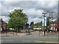
Poets' Corner Home Zone
An initiative to reduce traffic speeds in residential areas in Wolverhampton is being rolled out to other neighbourhoods.
Image: © John M
Taken: 7 May 2007
0.09 miles
6
Shelley Road near Bushbury in Wolverhampton
Looking north-north-east across the junction with Three Tuns Lane.
Image: © Roger Kidd
Taken: 29 Nov 2021
0.09 miles
7
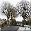
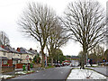
Three Tuns Lane near Elston Hall in Wolverhampton
Looking east-south-east towards Low Hill and Old Fallings. The snow is a remnant of the 6-8cm dumped by Storm Arwen three days earlier.
The West Coast Main Line from Manchester, Stoke-on-Trent and Stafford crosses here. Beyond the bridge, the road becomes Elston Hall Lane.
Image: © Roger Kidd
Taken: 29 Nov 2021
0.09 miles
8
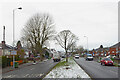
Three Tuns Lane near Elston Hall in Wolverhampton
Looking north-west towards the A449 Stafford Road. Ahead, Crathorne Avenue is off to the left. The snow is a remnant of the 6-8cm dumped by Storm Arwen three days earlier.
Image: © Roger Kidd
Taken: 29 Nov 2021
0.09 miles
9
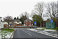
Church Road near Elston Hall in Wolverhampton
Looking north towards the junction with Three Tuns Lane.
Image: © Roger Kidd
Taken: 29 Nov 2021
0.09 miles
10
Three Tuns Lane near Bushbury in Wolverhampton
Looking east-south-east towards Elston Hall and Bushbury. The snow is a remnant of the 6-8cm which fell during Storm Arwen three days before.
Image: © Roger Kidd
Taken: 29 Nov 2021
0.10 miles