IMAGES TAKEN NEAR TO
Copes Crescent, WOLVERHAMPTON, WV10 0SL
Introduction
This page details the photographs taken nearby to Copes Crescent, WV10 0SL by members of the Geograph project.
The Geograph project started in 2005 with the aim of publishing, organising and preserving representative images for every square kilometre of Great Britain, Ireland and the Isle of Man.

There are currently over 7.5m images from over14,400 individuals and you can help contribute to the project by visiting https://www.geograph.org.uk
Image Map
Images are licensed for reuse under creativecommons.org/licenses/by-sa/2.0
Notes
- Clicking on the map will re-center to the selected point.
- The higher the marker number, the further away the image location is from the centre of the postcode.
Image Listing (20 Images Found)
Images are licensed for reuse under creativecommons.org/licenses/by-sa/2.0
Image
Details
Distance
1
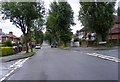
D'eyncourt Road
The view down the road in a Wolverhampton 1930s housing estate.
Image: © Gordon Griffiths
Taken: 11 Jul 2008
0.08 miles
2
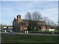
St Mary's RC Church
Primary school, church and presbytery all occupy this site on the Cannock Road.
Image: © John M
Taken: 4 Feb 2007
0.18 miles
3
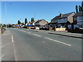
The A460 Cannock Road
1960s housing on the east side of the Cannock Road, heading out of Wolverhampton.
Image: © Richard Law
Taken: 7 Sep 2012
0.19 miles
4
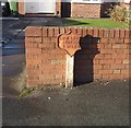
'Low Level Station 2 Miles'
A rare surviving milepost from a bygone era.
The GWR station opened in 1854 and was the most northerly broad gauge station. It was re-named as Low Level in 1856 to distinguish it from the adjacent LMS High Level Station. The station closed to passenger traffic in 1972.
Image: © John M
Taken: 3 Jan 2010
0.21 miles
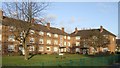
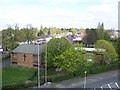
5
Queen's Court
Council housing dating from 1950. The facing block on Kingsway is Princess' Court.
Image: © John M
Taken: 26 Oct 2008
0.21 miles
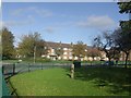
6
Council Housing - Queens Court
The Newlands Estate saw the first flats to be built in Wolverhampton in 1950. Queens Court and Princess Court are on opposite sides of Kingsway.
Image: © John M
Taken: 14 Jan 2011
0.21 miles
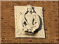
7
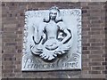
Emblem at Princess Court
Princess Court and Queens Court were the first council flats built in Wolverhampton.
Image: © John M
Taken: 14 Jan 2011
0.21 miles
8
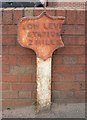
Old Milepost by the A460, Cannock Road, Old Fallings, Wolverhampton
Cast iron post by the A460, in parish of WOLVERHAMPTON (WOLVERHAMPTON District), Cannock Road; Old Fallings, just South of the junction of Croft and Leason Lanes, against garden wall of No. 677, on West side of road. Erected by an unknown authority in the 19th century.
Inscription reads:- : LOW LEVE(L) / STATION / 2 MILES :
Milestone Society National ID: ST_WVLL02
Image: © Mike Faherty
Taken: 13 Mar 2008
0.21 miles
9
Council Housing - Queens Court
Princess Court and Queens Court were the first council flats built in Wolverhampton.
Image: © John M
Taken: 14 Jan 2011
0.21 miles
10
Old Fallings United Reformed Church
Taken from the tower of Our Lady Of Perpetual Succour RC Church
Image: © Geoff Pick
Taken: 11 Apr 2011
0.22 miles