IMAGES TAKEN NEAR TO
Cannock Road, WOLVERHAMPTON, WV10 0RW
Introduction
This page details the photographs taken nearby to Cannock Road, WV10 0RW by members of the Geograph project.
The Geograph project started in 2005 with the aim of publishing, organising and preserving representative images for every square kilometre of Great Britain, Ireland and the Isle of Man.

There are currently over 7.5m images from over14,400 individuals and you can help contribute to the project by visiting https://www.geograph.org.uk
Image Map
Images are licensed for reuse under creativecommons.org/licenses/by-sa/2.0
Notes
- Clicking on the map will re-center to the selected point.
- The higher the marker number, the further away the image location is from the centre of the postcode.
Image Listing (42 Images Found)
Images are licensed for reuse under creativecommons.org/licenses/by-sa/2.0
Image
Details
Distance
1
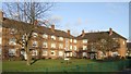
Council Housing - Queens Court
The Newlands Estate saw the first flats to be built in Wolverhampton in 1950. Queens Court and Princess Court are on opposite sides of Kingsway.
Image: © John M
Taken: 14 Jan 2011
0.03 miles
2
Queen's Court
Council housing dating from 1950. The facing block on Kingsway is Princess' Court.
Image: © John M
Taken: 26 Oct 2008
0.03 miles
3
Council Housing - Queens Court
Princess Court and Queens Court were the first council flats built in Wolverhampton.
Image: © John M
Taken: 14 Jan 2011
0.04 miles
4
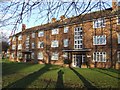
Council Housing - Princess Court
The Newbolds Estate built in 1950 was the first development of flats in Wolverhampton.
Image: © John M
Taken: 14 Jan 2011
0.04 miles
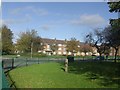
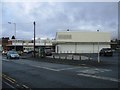
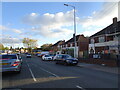
5
Fallings Park Shopping Centre
The supermarket and shopping centre were built in the early 1960s on the site of the Clifton Cinema.
Image: © John M
Taken: 4 Feb 2007
0.05 miles
6
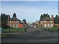
Entrance to TA Headquarters
Regimental Headquarters of 'The West Midlands Regiment'
Image: © John M
Taken: 4 Feb 2007
0.05 miles
7
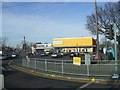
Former supermarket
Very much a tale of the minor players in the food retailing sector. On the site of the Clifton Cinema it originally opened in the 1960s as a Fine Fare, rebranded as Gateway, later becoming a Somerfield and more recently a Co-op. I would expect to see the site bulldozed. Maybe we will get another nursing home.
Image: © John M
Taken: 22 Nov 2015
0.06 miles
8
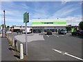
Fallings Park, food store
The Co-operative Food, on Raynor Road.
Image: © Mike Faherty
Taken: 30 Jun 2013
0.06 miles
9
Raynor Road Shops
The view in Bushbury, Wolverhampton.
Image: © Gordon Griffiths
Taken: 4 Nov 2021
0.06 miles
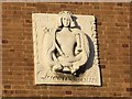
10
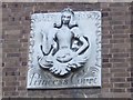
Emblem at Princess Court
Princess Court and Queens Court were the first council flats built in Wolverhampton.
Image: © John M
Taken: 14 Jan 2011
0.07 miles