IMAGES TAKEN NEAR TO
Hobgate Road, WOLVERHAMPTON, WV10 0PW
Introduction
This page details the photographs taken nearby to Hobgate Road, WV10 0PW by members of the Geograph project.
The Geograph project started in 2005 with the aim of publishing, organising and preserving representative images for every square kilometre of Great Britain, Ireland and the Isle of Man.

There are currently over 7.5m images from over14,400 individuals and you can help contribute to the project by visiting https://www.geograph.org.uk
Image Map
Images are licensed for reuse under creativecommons.org/licenses/by-sa/2.0
Notes
- Clicking on the map will re-center to the selected point.
- The higher the marker number, the further away the image location is from the centre of the postcode.
Image Listing (61 Images Found)
Images are licensed for reuse under creativecommons.org/licenses/by-sa/2.0
Image
Details
Distance
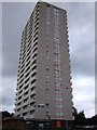
1
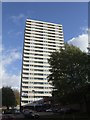
Council Housing - Brockfield House
The flats on the Heath Town Estate were opened by Princess Margaret in 1969.
Image: © John M
Taken: 13 Nov 2010
0.02 miles
2
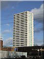
Council Housing - Heath Town Flats
The high rise estate was opened by Princess Margaret in 1969.
Image: © John M
Taken: 13 Nov 2010
0.04 miles
3
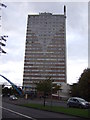
Tower block off Wolverhampton Road
Windows wide open 20+ storeys up - scary! Hope they don't have kids or animals.
Image: © JThomas
Taken: 5 Oct 2013
0.08 miles
4
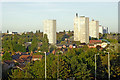
Tower blocks north-east of Wolverhampton Station
This telephoto assisted image was taken from the footbridge crossing lines at Wolverhampton Station.
The closest of the five visible tower blocks in the Heath Town district is about 930 metres distant. Considerable extra scrutiny is being applied to the safety and build quality of these structures since the appalling fire and disclosures following the Grenfell Tower conflagration in London in June 2017.
Several other mid 2oth century tower blocks in Wolverhampton have already been demolished, quite indepently from that incident
Image: © Roger Kidd
Taken: 27 Sep 2018
0.09 miles
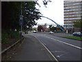
7
Heera Banqueting Suite (former Heath Town WMC)
The former 'Working Mens Club' is now a venue for Bhangra nights, functions and weddings.
Image: © John M
Taken: 13 Nov 2010
0.10 miles
8
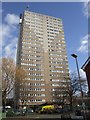
Council Housing - Heath Town Flats
The flats were opened by Princess Margaret in 1969. The estate featured a district heating scheme with a chimney attached to the side of the tower block. It is similar to Phoenix Rise at Blakenhall which is currently being demolished.
Image: © John M
Taken: 13 Nov 2010
0.10 miles
9
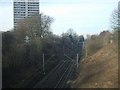
Railway in a deep cutting in Heath Town
This line is used primarily as a freight and diversion route.
Image: © John M
Taken: 4 Feb 2007
0.12 miles
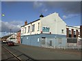
10
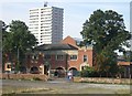
Heath Town Swimming Baths
The 1930s built swimming baths are soon to be replaced in winter of 2006 by a new leisure pool at Bentley Bridge.
Image: © John M
Taken: 9 Sep 2006
0.12 miles