IMAGES TAKEN NEAR TO
Cambridge Street, WOLVERHAMPTON, WV10 0JR
Introduction
This page details the photographs taken nearby to Cambridge Street, WV10 0JR by members of the Geograph project.
The Geograph project started in 2005 with the aim of publishing, organising and preserving representative images for every square kilometre of Great Britain, Ireland and the Isle of Man.

There are currently over 7.5m images from over14,400 individuals and you can help contribute to the project by visiting https://www.geograph.org.uk
Image Map
Images are licensed for reuse under creativecommons.org/licenses/by-sa/2.0
Notes
- Clicking on the map will re-center to the selected point.
- The higher the marker number, the further away the image location is from the centre of the postcode.
Image Listing (441 Images Found)
Images are licensed for reuse under creativecommons.org/licenses/by-sa/2.0
Image
Details
Distance
1
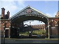
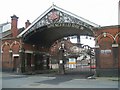
Springfield Brewery - Main Entrance
Grade II listed.
Image: © John M
Taken: 25 Oct 2013
0.00 miles
2
Brewery Entrance
The view of the former brewery which ceased production of 'Springfield Bitter' in 1991. The brewery was built in 1873 for William Butler and was taken over by Mitchells and Butlers in 1956.
Image: © Gordon Griffiths
Taken: 7 Nov 2014
0.00 miles
3
Water Street, Springfield
Rear of Freemasons Arm and butcher's shop.
Water Street marks the start of the course of the Smestow Brook which emerges from the nearby 'Spring Field' after which the brewery was named. The Smestow Brook is one of the two rivers which rise in Wolverhampton. It eventually flows into the River Stour at Stourton and River Severn at Stourport.
Image: © John M
Taken: 23 Feb 2008
0.02 miles
4
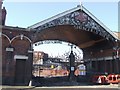
Springfield Brewery Redevelopment - Main Entrance
This 'listed' entrance canopy and the lodges date from 1880. The brewery itself dates from 1873 and was built for William Butler. The brewery site, disused for many years, is finally being developed for mixed use.
Image: © John M
Taken: 17 Feb 2008
0.02 miles
5
Springfield Brewery Redevelopment - Demolition
Image: © John M
Taken: 1 Jun 2008
0.04 miles
6
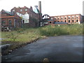
Springfield Brewery - Inside the courtyard
There is an argument that the former brewery complex should be demolished now before it deteriorates into such a state of repair that bulldozing is the only option left.
Image: © John M
Taken: 25 Oct 2013
0.04 miles
7

Springfield Brewery Redevelopment - Brewhouse
Will this fairly unattractive feature in the centre of the complex survive the demolition squad?
Image: © John M
Taken: 17 Feb 2008
0.04 miles
8
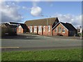
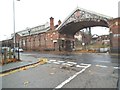
Former St Stephen's School - Springfield
The school was opened on this site in 1880 and the building was used until 1979 when it was handed over to Youth Services. The school continues at the former Woden Road School in Heath Town.
Image: © John M
Taken: 13 Nov 2010
0.04 miles
9
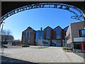
Former Springfield Brewery, Wolverhampton
This was built in 1873 for William Butler and has now been converted for use by the University of Wolverhampton. It had become derelict and fire damaged but the Grade II Listed tower brewery has been externally restored and extensions added for its new educational role. The original building is seen on the left.
Image: © Chris Allen
Taken: 24 Feb 2024
0.04 miles
10
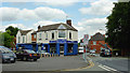
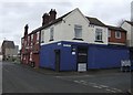
Butcher on Hilton Street, Springfield, Wolverhampton
Alan Garbett's butchery is a long established business (around sixty years) on the corner of Water Street and Hilton Street. The photographer is standing at the eastern end of Grimstone Street.
Image: © Roger D Kidd
Taken: 10 Aug 2012
0.05 miles