IMAGES TAKEN NEAR TO
Trent Gardens, WOLVERHAMPTON, WV10 0EL
Introduction
This page details the photographs taken nearby to Trent Gardens, WV10 0EL by members of the Geograph project.
The Geograph project started in 2005 with the aim of publishing, organising and preserving representative images for every square kilometre of Great Britain, Ireland and the Isle of Man.

There are currently over 7.5m images from over14,400 individuals and you can help contribute to the project by visiting https://www.geograph.org.uk
Image Map
Images are licensed for reuse under creativecommons.org/licenses/by-sa/2.0
Notes
- Clicking on the map will re-center to the selected point.
- The higher the marker number, the further away the image location is from the centre of the postcode.
Image Listing (174 Images Found)
Images are licensed for reuse under creativecommons.org/licenses/by-sa/2.0
Image
Details
Distance
1
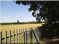
Football Field
The view in Springfield, Wolverhampton.
Image: © Gordon Griffiths
Taken: 20 Jun 2014
0.02 miles
2
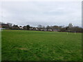
Playing fields south of Woden Primary School
Football fields which are presumably connected to, or owned by, the school; that said, the scale of the pitches and size of the goals seems a bit large for 'primary school' children.
Image: © Richard Law
Taken: 4 Feb 2025
0.05 miles
3
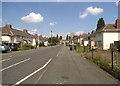
Burton Crescent
The view in Springfield, Wolverhampton.
Image: © Gordon Griffiths
Taken: 20 Jun 2014
0.05 miles
4
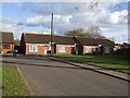
Social Housing - Field Street
Small development of bungalows in Springfield.
Image: © John M
Taken: 13 Nov 2010
0.07 miles
5
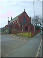
Saint Stephen the Martyr Church
A church in Hilton Street Springfield.
Image: © Gordon Griffiths
Taken: 9 Apr 2007
0.07 miles
6
Burton Road View
The view in Springfield, Wolverhampton.
Image: © Gordon Griffiths
Taken: 20 Jun 2014
0.07 miles
8
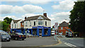
Butcher on Hilton Street, Springfield, Wolverhampton
Alan Garbett's butchery is a long established business (around sixty years) on the corner of Water Street and Hilton Street. The photographer is standing at the eastern end of Grimstone Street.
Image: © Roger D Kidd
Taken: 10 Aug 2012
0.08 miles
9
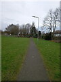
Footpath behind Springfield Road, Wolverhampton
The path runs from a small play area just north of Burton Road, past the Sea Cadets base in the trees, to join Springfield Road beside Woden Primary School.
Image: © Richard Law
Taken: 4 Feb 2025
0.08 miles
10
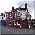
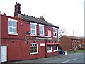
Masons Arms Hilton Street
Previously called The Freemasons Arms
Image: © PAUL FARMER
Taken: 5 Apr 2009
0.08 miles