IMAGES TAKEN NEAR TO
Woden Road, WOLVERHAMPTON, WV10 0BB
Introduction
This page details the photographs taken nearby to Woden Road, WV10 0BB by members of the Geograph project.
The Geograph project started in 2005 with the aim of publishing, organising and preserving representative images for every square kilometre of Great Britain, Ireland and the Isle of Man.

There are currently over 7.5m images from over14,400 individuals and you can help contribute to the project by visiting https://www.geograph.org.uk
Image Map
Images are licensed for reuse under creativecommons.org/licenses/by-sa/2.0
Notes
- Clicking on the map will re-center to the selected point.
- The higher the marker number, the further away the image location is from the centre of the postcode.
Image Listing (26 Images Found)
Images are licensed for reuse under creativecommons.org/licenses/by-sa/2.0
Image
Details
Distance
1
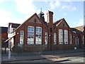
Woden Road Junior School
The school dates from 1898 and was contemporary with the surrounding Victorian terrace housing. The housing was demolished in the late 1960s and replaced with the high rise Heath Town Estate.
Image: © John M
Taken: 13 Nov 2010
0.13 miles
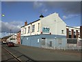
2
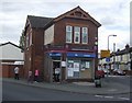
Corner shop at junction of Powell Street and Leslie Road
This looks as if it started life as a public house. The painted signs on the walls are for Butlers Ales.
Image: © John M
Taken: 1 May 2010
0.14 miles
3
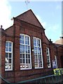
Woden Road School
The school dates from 1898 and was contemporary with the surrounding Victorian terrace housing. The housing was demolished in the late 1960s and replaced with the high rise Heath Town Estate.
Image: © John M
Taken: 13 Nov 2010
0.14 miles
4
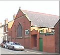
Stratton Street Methodist Church
At the North of the Grid Square in Park Village. The Church was the first building on the road and has been there since 1906.
Image: © Mike Jackson
Taken: 2 Aug 2000
0.15 miles
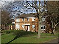
5
Heera Banqueting Suite (former Heath Town WMC)
The former 'Working Mens Club' is now a venue for Bhangra nights, functions and weddings.
Image: © John M
Taken: 13 Nov 2010
0.16 miles
6
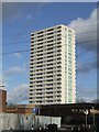
Council Housing - Heath Town Flats
The high rise estate was opened by Princess Margaret in 1969.
Image: © John M
Taken: 13 Nov 2010
0.18 miles
7
Council Housing - Leslie Street
Small infill estate of houses beside the Cannock Road in Park Village probably dating from the mid 1970s.
Image: © John M
Taken: 13 Nov 2010
0.18 miles
8
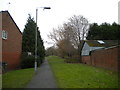
Footpath to Langsett Road, Park Village
From Cannock Road.
Image: © Richard Vince
Taken: 27 Dec 2017
0.19 miles
9
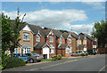
Modern housing in Springfield, Wolverhampton
Langsett Road is a cul-de-sac off Springfield Road.
Image: © Roger D Kidd
Taken: 10 Aug 2012
0.19 miles
10
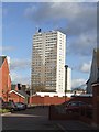
Council Housing - Heath Town Flats
The Heath Town Estate was opened by Princess Margaret in 1969.
Image: © John M
Taken: 13 Nov 2010
0.19 miles