IMAGES TAKEN NEAR TO
Tremaine Gardens, WOLVERHAMPTON, WV10 0AP
Introduction
This page details the photographs taken nearby to Tremaine Gardens, WV10 0AP by members of the Geograph project.
The Geograph project started in 2005 with the aim of publishing, organising and preserving representative images for every square kilometre of Great Britain, Ireland and the Isle of Man.

There are currently over 7.5m images from over14,400 individuals and you can help contribute to the project by visiting https://www.geograph.org.uk
Image Map
Images are licensed for reuse under creativecommons.org/licenses/by-sa/2.0
Notes
- Clicking on the map will re-center to the selected point.
- The higher the marker number, the further away the image location is from the centre of the postcode.
Image Listing (277 Images Found)
Images are licensed for reuse under creativecommons.org/licenses/by-sa/2.0
Image
Details
Distance
1
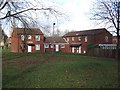
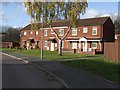
Council Housing - Tremaine Gardens
Late 1980s housing estate replacing Victorian terraces next to Springfield Brewery. A curiously large open space with trees forms a central feature of the estate.
Image: © John M
Taken: 13 Nov 2010
0.03 miles
2
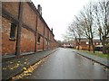
Yarwell Street
The view near the former Springfield brewery in Wolverhampton.
Image: © Gordon Griffiths
Taken: 8 Nov 2014
0.04 miles
3
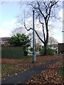
Sewer Vent Pipe - Tremaine Gardens
A remnant from the period of the Victorian terraced housing demolished in the 1980s and replaced by council housing. There are a number of these vent pipes around the city including Grade II and locally listed examples.
Image: © John M
Taken: 13 Nov 2010
0.04 miles
4

Council Housing - Tremaine Gardens
Late 1980s housing in a woodland setting.
Image: © John M
Taken: 13 Nov 2010
0.04 miles
5
Derelict land and building in Springfield, Wolverhampton
This ex Springfield Brewery site is earmarked for development by Bryant Homes. One/two bedroom apartments, and three/four bedroom houses are planned.
Image: © Roger D Kidd
Taken: 10 Aug 2012
0.05 miles
6
Council Housing - Tremaine Gardens
Late 1980s housing estate replacing Victorian terraces next to Springfield Brewery.
Image: © John M
Taken: 13 Nov 2010
0.05 miles
7
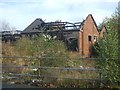
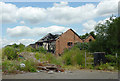
Derelict brewery buildings - Springfield Brewery
Bryant Homes have plans for a housing development on this site but appear to have delayed the start. In the meantime the local youths have torched the few remaining buildings.
Image: © John M
Taken: 3 Nov 2012
0.05 miles
8

Cannock Road in Springfield, Wolverhampton
This is the A460 Cannock Road, looking north-west towards Featherstone and Cannock.
Image: © Roger Kidd
Taken: 14 May 2022
0.06 miles
9
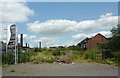
Derelict land in Springfield, Wolverhampton
Formerly part of the Springfield Brewery site, the land east of Cambridge Street has been almost cleared, ready for housing development by Bryant Homes. Other brewery buildings which may be preserved can be seen to the left. Andy Brough now has his own brewery in situ there and is producing four good ales.
Image: © Roger D Kidd
Taken: 10 Aug 2012
0.06 miles
10
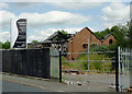
Derelict land and building in Springfield, Wolverhampton
Seen from Cambridge Street, this ex Springfield Brewery site is earmarked for development by Bryant Homes. One/two bedroom apartments, and three/four bedroom houses are planned.
Image: © Roger D Kidd
Taken: 10 Aug 2012
0.06 miles