IMAGES TAKEN NEAR TO
Swan Close, WALSALL, WS6 7LF
Introduction
This page details the photographs taken nearby to Swan Close, WS6 7LF by members of the Geograph project.
The Geograph project started in 2005 with the aim of publishing, organising and preserving representative images for every square kilometre of Great Britain, Ireland and the Isle of Man.

There are currently over 7.5m images from over14,400 individuals and you can help contribute to the project by visiting https://www.geograph.org.uk
Image Map (Loading...)


Getting Data...Please wait
Leaflet Map data © OpenStreetMap
Images are licensed for reuse under creativecommons.org/licenses/by-sa/2.0
Notes
- Clicking on the map will re-center to the selected point.
- The higher the marker number, the further away the image location is from the centre of the postcode.
Image Listing (5 Images Found)
Images are licensed for reuse under creativecommons.org/licenses/by-sa/2.0
Image
Details
Distance
1
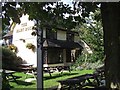
The Mary Rose, Cheslyn Hay
Converted in 1982 from a farmhouse, this modern pub manages to feel older
Image: © Geoff Pick
Taken: 2 Oct 2006
0.12 miles
2
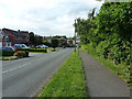
Moons Lane approaching Dundalk Lane
In the housing estates of southern Cheslyn Hay.
Image: © Richard Law
Taken: 14 Jun 2017
0.14 miles
4
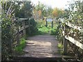
Footbridge over the Wyrley Branch Canal
This footbridge is located at the site of a former swing bridge on the Wyrley Branch Canal.
Image: © John M
Taken: 12 Nov 2006
0.24 miles
5
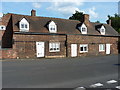
14 & 16, Dundalk Lane
Close to the centre of Cheslyn Hay lies this remarkable terrace of 3 cottages, which date in appearance from the early 18th century, but actually have a 17th century timber-framed heart, some of which is still exposed in the left gable end (in shadow here) and at the rear. They were Grade II listed https://www.britishlistedbuildings.co.uk/101039171-14-and-16-dundalk-lane-cheslyn-hay#.WV55YtQrLGg in 1980.
Image: © Richard Law
Taken: 14 Jun 2017
0.25 miles