IMAGES TAKEN NEAR TO
Spring Drive, WALSALL, WS6 6DG
Introduction
This page details the photographs taken nearby to Spring Drive, WS6 6DG by members of the Geograph project.
The Geograph project started in 2005 with the aim of publishing, organising and preserving representative images for every square kilometre of Great Britain, Ireland and the Isle of Man.

There are currently over 7.5m images from over14,400 individuals and you can help contribute to the project by visiting https://www.geograph.org.uk
Image Map
Images are licensed for reuse under creativecommons.org/licenses/by-sa/2.0
Notes
- Clicking on the map will re-center to the selected point.
- The higher the marker number, the further away the image location is from the centre of the postcode.
Image Listing (6 Images Found)
Images are licensed for reuse under creativecommons.org/licenses/by-sa/2.0
Image
Details
Distance
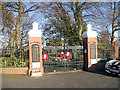
2
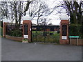
Memorial gates
Great War memorial park in Great Wyrley.
Image: © John M
Taken: 24 Mar 2008
0.20 miles
3
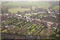
Junction of Hilton Lane and the A34
The junction is where the small shop like feature is. This photograph was taken from a hot air balloon.
Image: © Angella Streluk
Taken: 29 Apr 2006
0.21 miles
6
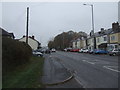
Walsall Road (A34), Great Wyrley
Towards Cannock.
Image: © JThomas
Taken: 9 Nov 2019
0.24 miles