
IMAGES TAKEN NEAR TO
Lichfield Street, WALSALL, WS4 2BY
Introduction
This page details the photographs taken nearby to Lichfield Street, WS4 2BY by members of the Geograph project.
The Geograph project started in 2005 with the aim of publishing, organising and preserving representative images for every square kilometre of Great Britain, Ireland and the Isle of Man.

There are currently over 7.5m images from over14,400 individuals and you can help contribute to the project by visiting https://www.geograph.org.uk
Image Map
Images are licensed for reuse under creativecommons.org/licenses/by-sa/2.0
Notes
- Clicking on the map will re-center to the selected point.
- The higher the marker number, the further away the image location is from the centre of the postcode.
Image Listing (60 Images Found)
Images are licensed for reuse under creativecommons.org/licenses/by-sa/2.0
Image
Details
Distance
1
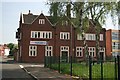
The BB Pub
This old pub now seems to have the name "BB". It's not a pub I know or have ever frequented, but it's an interesting old building.
Image: © Derek Bennett
Taken: 11 May 2008
0.04 miles
2
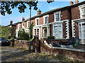
3 & 4 Victoria Terrace, Walsall
Built in the 1850s as part of the landscaping works of the Arboretum, to a design of Henry Farrington, and Grade II listed https://britishlistedbuildings.co.uk/101186738-3-and-4-victoria-terrace-st-matthews-ward#.XAWiFtSLTGg in 1971, along with all the other houses of a very similar design to either side.
Image: © Richard Law
Taken: 24 Oct 2018
0.05 miles
3

Walsall Arboretum lodge (detail) by Lichfield Street
This Lodge is by the Lichfield Road entrance to the park, at the northern end of Hatherton Lake.
The image has been scanned from an Agfacolor transparency dating from c1972-3.
Image: © Roger D Kidd
Taken: 1 Jan 1972
0.06 miles
4
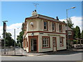
The Hatherton Arms
Butts Road, Walsall.
See this pub in a rather ghastly pale blue here: Image
Image: © Adrian Rothery
Taken: 1 Aug 2008
0.06 miles
5
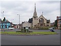
Derelict Methodist Church, Walsall
This is the view that greets drivers as they arrive in the town on the A454 from Aldridge. Structurally unsafe, it can't be long before the church is pulled down. It was built in 1910 and provides an interesting symmetry with the equally grand methodist church at the start of the A454 in Sutton Coldfield (Image).
Image: © Adrian Bailey
Taken: 31 Jul 2005
0.07 miles
6

Walsall Arboretum
Boating lake and boat house.
Image: © Adrian Rothery
Taken: 5 Oct 2007
0.07 miles
7
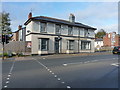
The Hatherton Arms, Walsall
Back in 2011, Image was looking a lot more lively (and open) than it does now.
Image: © Richard Law
Taken: 24 Oct 2018
0.08 miles
8
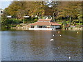
Hatherton Lake boathouse
Built around 1874 for the Walsall Arboretum and Lake Co. Ltd, possibly to the design of the county surveyor, named Robert Griffiths. The boathouse is timber-framed with cast-iron columns to the embarkation area, and was Grade II listed https://britishlistedbuildings.co.uk/101391118-the-boat-house-adjoining-hatherton-lake-in-walsall-aboretum-st-matthews-ward#.XAWfo9SLTGg in 2004 as an important feature within a Victorian municipal park landscape.
Image: © Richard Law
Taken: 24 Oct 2018
0.08 miles
9
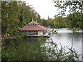
Refurbishment of boathouse
Walsall Arboretum's boathouse is amongst the many buildings in the park that are currently being worked on
Image: © Michael Westley
Taken: 9 Oct 2011
0.08 miles
10
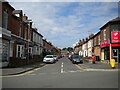
Westbourne Street, Walsall
Off Butts Road.
Image: © Richard Vince
Taken: 29 May 2021
0.08 miles