IMAGES TAKEN NEAR TO
Crown Wharf Shopping Park, Wolverhampton Street, WALSALL, WS2 8LL
Introduction
This page details the photographs taken nearby to Crown Wharf Shopping Park, Wolverhampton Street, WS2 8LL by members of the Geograph project.
The Geograph project started in 2005 with the aim of publishing, organising and preserving representative images for every square kilometre of Great Britain, Ireland and the Isle of Man.

There are currently over 7.5m images from over14,400 individuals and you can help contribute to the project by visiting https://www.geograph.org.uk
Image Map
Images are licensed for reuse under creativecommons.org/licenses/by-sa/2.0
Notes
- Clicking on the map will re-center to the selected point.
- The higher the marker number, the further away the image location is from the centre of the postcode.
Image Listing (127 Images Found)
Images are licensed for reuse under creativecommons.org/licenses/by-sa/2.0
Image
Details
Distance
2
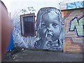
Graffiti on the old Reginald Tildesley garage
Wolverhampton Street, Walsall.
Image: © Adrian Rothery
Taken: 9 Mar 2007
0.07 miles
3
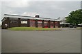
Walsall fire station
Walsall fire station, Blue Lane West, Walsall forms part of the West Midlands Fire & Rescue Service.
Image: © Kevin Hale
Taken: 12 Jun 2006
0.09 miles
4
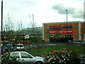
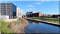
Crown Wharf Shopping Park
Junction of Blue Lane West and Wolverhampton Street.
Image: © Adrian Rothery
Taken: 14 Aug 2008
0.09 miles
5
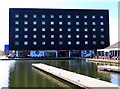
The Premier Inn and Brewers Fayre by the Town Basin
Image: © Steve Daniels
Taken: 10 Apr 2019
0.09 miles
7
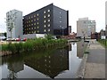
Premier Inn, Walsall
The Premier Inn and Brewers Fayre reflected in the Walsall Canal.
Image: © Philip Halling
Taken: 8 Jun 2018
0.09 miles
8
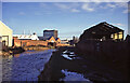
Branch canal to Walsall town centre
This is no more than a guess based on identifying the multistorey block above Wilko and the Town Hall in the distance. If I am right none of the buildings in the foreground and middle distance survive. I have more pictures on the same day but cannot locate them with any accuracy.
If anybody can locate this better I would be grateful.
Image: © Chris Allen
Taken: 18 Dec 1994
0.10 miles
9

Walsall - Salvation Army citadel
On Green Lane.
Image: © Dave Bevis
Taken: 12 Apr 2014
0.10 miles
10
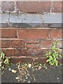
OS Cut Mark: Walsall, Salvation Army Building on Green Lane
Ordnance Survey Cut Mark: Walsall, Salvation Army Building on Green Lane
Image: © thejackrustles
Taken: 7 Jun 2014
0.10 miles