IMAGES TAKEN NEAR TO
Hollyhill Road, LICHFIELD, WS14 0JF
Introduction
This page details the photographs taken nearby to Hollyhill Road, WS14 0JF by members of the Geograph project.
The Geograph project started in 2005 with the aim of publishing, organising and preserving representative images for every square kilometre of Great Britain, Ireland and the Isle of Man.

There are currently over 7.5m images from over14,400 individuals and you can help contribute to the project by visiting https://www.geograph.org.uk
Image Map
Images are licensed for reuse under creativecommons.org/licenses/by-sa/2.0
Notes
- Clicking on the map will re-center to the selected point.
- The higher the marker number, the further away the image location is from the centre of the postcode.
Image Listing (19 Images Found)
Images are licensed for reuse under creativecommons.org/licenses/by-sa/2.0
Image
Details
Distance
1
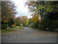
Hollyhill Road, Shenstone
Off St John's Hill.
Image: © Richard Vince
Taken: 13 Nov 2021
0.06 miles
2
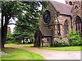
Shenstone church
This church can be seen as a landmark from around Shenstone, being on a hill with its tower often visible.
Image: © Pelham Arno
Taken: Unknown
0.10 miles
3
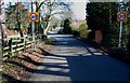
Road Junction on Hollyhill Lane, Shenstone
Image: © Mick Malpass
Taken: 11 Feb 2012
0.12 miles
4
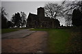
Church of St John the Baptist, Shenstone
Seen, appropriately enough, from St John's Hill.
Image: © Richard Vince
Taken: 13 Nov 2021
0.13 miles
5
St John's Church - Shenstone, Staffordshire
Standing high in this exposed position is the parish church of St John. Built in 1853/4 (?) during the 47 year term of vicar Robert Essington it replaced the previous parish church nearby. In the churchyard is buried Admiral Sir William Parker, one of Nelson's captains, he died in 1866. Time photo taken 11.44 am GMT (Greenwich Mean Time). Sources: The King's England - Staffordshire by Arthur Mee and The Staffordshire Village Book - Staffordshire Federation of Women's Institutes and Countryside Books.
Image: © Martin Richard Phelan
Taken: 10 Feb 2020
0.13 miles
6
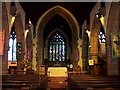
Interior, St. John The Baptist, Shenstone
Image: © Geoff Pick
Taken: 19 May 2007
0.14 miles
7
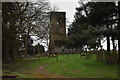
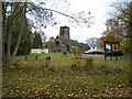
Old church from back then - Shenstone, Staffordshire
Standing nearby are the remains of the previous parish church of Shenstone. This was replaced in 1853/4 (?) by the present parish church of St John. During its demolition funds ran out leaving the tower standing. During my visit here the icy cold, high winds and driving rain encouraged a quick return to the Birmingham Road and the Bulls Head for lunch. Time photo taken 11.51 am GMT (Greenwich Mean Time). Sources: The King's England - Staffordshire by Arthur Mee and The Staffordshire Village Book - Staffordshire Federation of Women's Institutes and Countryside Books.
Image: © Martin Richard Phelan
Taken: 10 Feb 2020
0.15 miles
8
Footherley Road, Shenstone
Off St John's Hill.
Image: © Richard Vince
Taken: 13 Nov 2021
0.16 miles
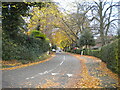
10
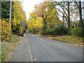
St John's Hill, Shenstone
Ascending from the junction with Schoolfields Road.
Image: © Richard Vince
Taken: 13 Nov 2021
0.17 miles