IMAGES TAKEN NEAR TO
Old Forge Close, WALSALL, WS1 3EA
Introduction
This page details the photographs taken nearby to Old Forge Close, WS1 3EA by members of the Geograph project.
The Geograph project started in 2005 with the aim of publishing, organising and preserving representative images for every square kilometre of Great Britain, Ireland and the Isle of Man.

There are currently over 7.5m images from over14,400 individuals and you can help contribute to the project by visiting https://www.geograph.org.uk
Image Map
Images are licensed for reuse under creativecommons.org/licenses/by-sa/2.0
Notes
- Clicking on the map will re-center to the selected point.
- The higher the marker number, the further away the image location is from the centre of the postcode.
Image Listing (20 Images Found)
Images are licensed for reuse under creativecommons.org/licenses/by-sa/2.0
Image
Details
Distance
1
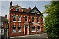
The White Lion Public House
This is one of Walsall's older pubs in Sandwell Street, Little London, Caldmore.
Image: © Derek Bennett
Taken: 11 May 2008
0.05 miles
2
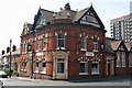
White Lion pub
This is the White Lion public house in Sandwell Street, Little London, Walsall. This pub is one of the Caldmore areas older pubs and is still a fine traditional ale house, it has undergone some much needed renovations and now looks set to continuing serving its thirsty customers for a few more years to come.
Image: © Derek Bennett
Taken: 11 May 2008
0.05 miles
3
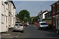
Sandwell Street Walsall
Sandwell Street is in the old part of Walsall in the Highgate area.
Image: © Derek Bennett
Taken: 11 May 2008
0.06 miles
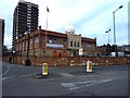
4
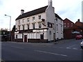
The Crown and Anchor
A currently-closed pub on the corner of West Bromwich Street and Little London.
Image: © Richard Law
Taken: 14 Mar 2013
0.09 miles
5
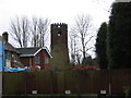
The Old Windmill at Highgate, Walsall
This old mill was built in the early 19th century. Its sails have long gone and the top of it has been altered as can be seen. It was once used as an amateur astronomical observatory and during the last war was manned every night by local air raid wardens as it was the highest point in the area. It can be seen from the top of Highgate Road which used to be called Windmill Lane. The area is generally known as 'The Windmill'.
Image: © Frank Smith
Taken: 8 Mar 2006
0.10 miles
6
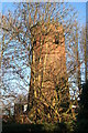
Highgate Windmill, Walsall
A long derelict tower mill that is largely obscured by trees from any direction.
It took a good long time to find this and the locals we asked were largely clueless. Eventually it was a case of spotting it by looking in a direction we didn't expect to see it in when we were on the point of throwing in the towel.
Image: © Chris Allen
Taken: 5 Dec 2010
0.10 miles
7
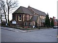
St Michaels and All Angels, Caldmore
A substantial stone-built church at the corner of Bath Road and St Michael Street.
Image: © Richard Law
Taken: 14 Mar 2013
0.11 miles
8
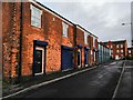
Windmill Street, Walsall
Off Sandwell Street, Walsall. This row of terraced houses are now offices. One of the doors was the entrance to the now defunct Windmill public house, but I can't remember which one.
Image: © Frank Smith
Taken: 7 Feb 2019
0.14 miles
9
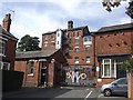
Highgate Brewery
The gates mark the centenary of brewing on this site in 2008.
Image: © John M
Taken: 8 Sep 2012
0.15 miles
10
Guru Nanak Sikh temple
A large temple in the Caldmore area of Walsall, on the junction of West Bromwich Street and Vincent Street.
Image: © Richard Law
Taken: 14 Mar 2013
0.15 miles