IMAGES TAKEN NEAR TO
Rudge Street, LICHFIELD, WS13 8FZ
Introduction
This page details the photographs taken nearby to Rudge Street, WS13 8FZ by members of the Geograph project.
The Geograph project started in 2005 with the aim of publishing, organising and preserving representative images for every square kilometre of Great Britain, Ireland and the Isle of Man.

There are currently over 7.5m images from over14,400 individuals and you can help contribute to the project by visiting https://www.geograph.org.uk
Image Map
Images are licensed for reuse under creativecommons.org/licenses/by-sa/2.0
Notes
- Clicking on the map will re-center to the selected point.
- The higher the marker number, the further away the image location is from the centre of the postcode.
Image Listing (10 Images Found)
Images are licensed for reuse under creativecommons.org/licenses/by-sa/2.0
Image
Details
Distance
1
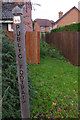
Footpath at Streethay
Although marked by this post on the A5127, the path leading down between the garden fences is evidently not well used.
Image: © Stephen McKay
Taken: 11 Dec 2013
0.15 miles
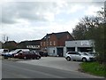
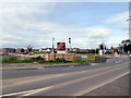
2
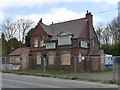
The Anchor Inn
Closed in 2015, windows boarded and fenced off, it is the subject of a contentious planning application to build three houses on the site.
Image: © Graham Hogg
Taken: 16 Apr 2018
0.17 miles
3
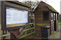
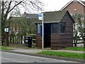
Bus shelter and notice board in Streethay
The notice board includes a request for comments on proposals for 750 new homes in Streethay.
Image: © Stephen McKay
Taken: 11 Dec 2013
0.17 miles
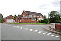
4
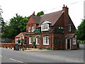
The Anchor, Streethay
Beside the A5127, Burton Road, Lichfield.
Image: © David Rogers
Taken: 27 Jun 2009
0.18 miles
7
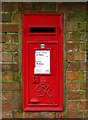
Streethay Postbox
GR VI postbox on Ash Tree Lane, near the junction with Burton Road.
Image: © David Rogers
Taken: 27 Jun 2009
0.20 miles
10
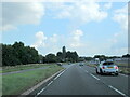
A38 northbound, A5127 joining from the left
Image: © Roy Hughes
Taken: 4 Aug 2021
0.24 miles