IMAGES TAKEN NEAR TO
Statham Street, LICHFIELD, WS13 6UN
Introduction
This page details the photographs taken nearby to Statham Street, WS13 6UN by members of the Geograph project.
The Geograph project started in 2005 with the aim of publishing, organising and preserving representative images for every square kilometre of Great Britain, Ireland and the Isle of Man.

There are currently over 7.5m images from over14,400 individuals and you can help contribute to the project by visiting https://www.geograph.org.uk
Image Map
Images are licensed for reuse under creativecommons.org/licenses/by-sa/2.0
Notes
- Clicking on the map will re-center to the selected point.
- The higher the marker number, the further away the image location is from the centre of the postcode.
Image Listing (6 Images Found)
Images are licensed for reuse under creativecommons.org/licenses/by-sa/2.0
Image
Details
Distance
3
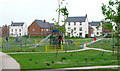
Trunkfield Playground
Beside Trunkfield Brook and close to Darwin Park.
Image: © David Rogers
Taken: 28 Jun 2009
0.11 miles
4
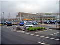
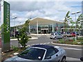
Waitrose at Lichfield
From the car park looking north to the front entrance. The building has a rather modernistic design with lots of glass.
Image: © Trevor Rickard
Taken: 21 Nov 2009
0.14 miles
5
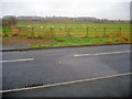
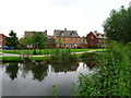
Sheep pasture near the Waitrose access road
Looking south from the edge of the Waitrose car park. Behind the meadow, the street lights mark the position of the A461 roundabout, with the railway embankment just beyond.
Image: © Trevor Rickard
Taken: 21 Nov 2009
0.18 miles
6
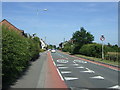
Walsall Road heading east
Towards Lichfield.
Image: © JThomas
Taken: 11 Jul 2013
0.23 miles