IMAGES TAKEN NEAR TO
St. Michael Road, LICHFIELD, WS13 6SN
Introduction
This page details the photographs taken nearby to St. Michael Road, WS13 6SN by members of the Geograph project.
The Geograph project started in 2005 with the aim of publishing, organising and preserving representative images for every square kilometre of Great Britain, Ireland and the Isle of Man.

There are currently over 7.5m images from over14,400 individuals and you can help contribute to the project by visiting https://www.geograph.org.uk
Image Map
Images are licensed for reuse under creativecommons.org/licenses/by-sa/2.0
Notes
- Clicking on the map will re-center to the selected point.
- The higher the marker number, the further away the image location is from the centre of the postcode.
Image Listing (102 Images Found)
Images are licensed for reuse under creativecommons.org/licenses/by-sa/2.0
Image
Details
Distance
1
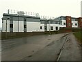
Rear of Darwin Court Care Home
Probably named after Erasmus Darwin of Lichfield rather than the more famous naturalist. The fence along the edge of the roof is due to it having a rooftop garden for residents.
Image: © Stephen Craven
Taken: 11 Mar 2023
0.11 miles
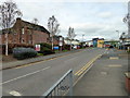
2
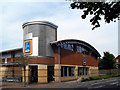
Lichfield Aldi
Geograph is so polite. There isn't a category for "eyesore" or "ugly building"
Even "pile of tat" would fit the bill, but we'll have to settle for "shop front".
Said with a sniff, though.
Image: © Des Blenkinsopp
Taken: 16 Aug 2010
0.12 miles
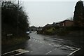
3
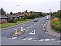
St Michaels Road
The view from Stowe Pool in Lichfield.
Image: © Gordon Griffiths
Taken: 30 Aug 2015
0.13 miles
4
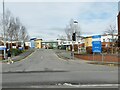
Samuel Johnson Hospital (2)
The modern buildings set back from Trent Valley Road.
Image: © Stephen Craven
Taken: 11 Mar 2023
0.13 miles
5

The rear of ALDI in Lichfield
On St Michael's Road. See Image for the front.
Image: © Stephen Craven
Taken: 11 Mar 2023
0.13 miles
6

Samuel Johnson Hospital (5)
One of the original workhouse buildings from 1840 by George Gilbert Scott and William Moffatt, this 'rear range' that originally comprised the Master's House, male and female wings, is grade II listed (list entry 1033360).
Image: © Stephen Craven
Taken: 11 Mar 2023
0.14 miles
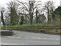
7
Junction on Wissage Road
The junction with Brownsfield Road.
Image: © DS Pugh
Taken: 11 Mar 2023
0.14 miles
8
Samuel Johnson Community Hospital, Lichfield
Image: © PAUL FARMER
Taken: 23 Apr 2018
0.14 miles
9
Start of Burton Old Road West
This has been the 'old' road for over 100 years.
Image: © Stephen Craven
Taken: 11 Mar 2023
0.15 miles
10
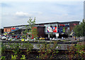
Lichfield Tesco
Looks better than Aldi's.
Image
Image: © Des Blenkinsopp
Taken: 16 Aug 2010
0.15 miles