IMAGES TAKEN NEAR TO
Lime Street, WALSALL, WS1 2JL
Introduction
This page details the photographs taken nearby to Lime Street, WS1 2JL by members of the Geograph project.
The Geograph project started in 2005 with the aim of publishing, organising and preserving representative images for every square kilometre of Great Britain, Ireland and the Isle of Man.

There are currently over 7.5m images from over14,400 individuals and you can help contribute to the project by visiting https://www.geograph.org.uk
Image Map
Images are licensed for reuse under creativecommons.org/licenses/by-sa/2.0
Notes
- Clicking on the map will re-center to the selected point.
- The higher the marker number, the further away the image location is from the centre of the postcode.
Image Listing (26 Images Found)
Images are licensed for reuse under creativecommons.org/licenses/by-sa/2.0
Image
Details
Distance
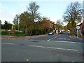
1
The Walsall Arms
The Walsall Arms is one of the town's old pubs.
Image: © Derek Bennett
Taken: 19 Sep 2018
0.08 miles
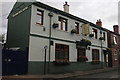
2
Snow over Walsall
Looking across Walsall's industrial units out to its suburbs from St Matthew's Church on a snowy day.
Image: © Derek Bennett
Taken: 14 Jan 2015
0.09 miles
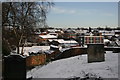
3
Across the rooftops, Walsall, Staffordshire
I must have been testing out my new 35-135mm zoom lens when I took this, probably from the grounds of St Matthew's Church, looking towards the tower blocks at The Chuckery. (That old Olympus OM20 SLR feels very heavy these days!) There are actually five towers. Three are clearly seen here, with another tall one poking out above the middle tower. In the centre is Tantarra Street, I think.
More on the tower blocks: http://www.watmos.org.uk/pages/a-tmo_p3.asp
The picture is from circa 1969-1972, I think, and scanned from a monochrome negative.
Image: © Roger D Kidd
Taken: 1 Jan 1972
0.11 miles
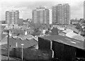
4
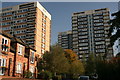
Tower Blocks
These ugly sixties built flats remind me of the old Soviet style tower blocks.
Image: © Derek Bennett
Taken: 12 Oct 2008
0.12 miles
5
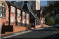
Sheltered Accommodation
This old school has been converted to sheltered accommodation for the who are little more mature in years.
Image: © Derek Bennett
Taken: 12 Oct 2008
0.13 miles
6
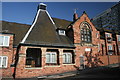
Tantara Street sheltered accommodation
This sheltered accommodation in Tantara Street, Walsall, is in an old school building.
Image: © Derek Bennett
Taken: 12 Oct 2008
0.14 miles
7
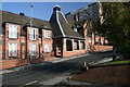
Sheltered Accommodation in Tantara Street
This was an old school building and is now sheltered accommodation.
Image: © Derek Bennett
Taken: 12 Oct 2008
0.14 miles
8
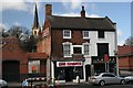
Car Spares & Chip shop
Old buildings on the way in to Walsall town centre.
Image: © Derek Bennett
Taken: 30 Mar 2008
0.17 miles
9
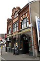
Flan O'Briens on Upper Rushall Street
Flan O'Briens is an Irish Bar on the corner of Upper Rushall Street and Ablewell Street.
Image: © Steve Daniels
Taken: 14 Jul 2014
0.20 miles