IMAGES TAKEN NEAR TO
Stanley Road, CANNOCK, WS12 4JS
Introduction
This page details the photographs taken nearby to Stanley Road, WS12 4JS by members of the Geograph project.
The Geograph project started in 2005 with the aim of publishing, organising and preserving representative images for every square kilometre of Great Britain, Ireland and the Isle of Man.

There are currently over 7.5m images from over14,400 individuals and you can help contribute to the project by visiting https://www.geograph.org.uk
Image Map
Images are licensed for reuse under creativecommons.org/licenses/by-sa/2.0
Notes
- Clicking on the map will re-center to the selected point.
- The higher the marker number, the further away the image location is from the centre of the postcode.
Image Listing (3 Images Found)
Images are licensed for reuse under creativecommons.org/licenses/by-sa/2.0
Image
Details
Distance
1
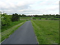
Stanley Road crosses the Pyegreen valley
Mapped as a byway, the original track has recently been surfaced and fenced at each end, which is presumably to discourage inappropriate vehicular access to this area of green space in Hednesford.
Image: © Richard Law
Taken: 31 May 2013
0.12 miles
2
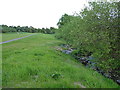
The Pyegreen brook
A small stream that flows southeastwards from Pye Green towards the built-up area of Hednesford, and then disappears underground into culverts and gets rather lost. Historic maps suggest that it later joins the Ridings Brook, flowing south towards Cannock.
Image: © Richard Law
Taken: 31 May 2013
0.16 miles
3

Staffordshire University Academy
To be fair, this is probably not the posh entrance to this school just outside Hednesford.
Image: © Richard Law
Taken: 22 Feb 2014
0.24 miles