IMAGES TAKEN NEAR TO
Ward Street, CANNOCK, WS12 4HQ
Introduction
This page details the photographs taken nearby to Ward Street, WS12 4HQ by members of the Geograph project.
The Geograph project started in 2005 with the aim of publishing, organising and preserving representative images for every square kilometre of Great Britain, Ireland and the Isle of Man.

There are currently over 7.5m images from over14,400 individuals and you can help contribute to the project by visiting https://www.geograph.org.uk
Image Map
Images are licensed for reuse under creativecommons.org/licenses/by-sa/2.0
Notes
- Clicking on the map will re-center to the selected point.
- The higher the marker number, the further away the image location is from the centre of the postcode.
Image Listing (8 Images Found)
Images are licensed for reuse under creativecommons.org/licenses/by-sa/2.0
Image
Details
Distance
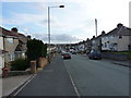
1

Staffordshire University Academy
To be fair, this is probably not the posh entrance to this school just outside Hednesford.
Image: © Richard Law
Taken: 22 Feb 2014
0.08 miles
2
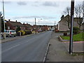
Belt Road, West Chadsmoor
Belt Road runs from Huntington down to Hednesford; Holly Street on the right.
Image: © Richard Law
Taken: 22 Feb 2014
0.12 miles
3
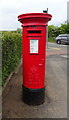
Elizabeth II postbox on Limepit Lane, Cannock
Postbox No. WS11 276.
See Image] for context.
Image: © JThomas
Taken: 18 May 2019
0.22 miles
4
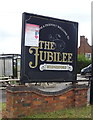
Sign for the Jubilee Inn, Hednesford, Cannock
See Image] for context.
Image: © JThomas
Taken: 18 May 2019
0.22 miles
6
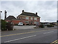
The Jubilee pub
A landmark pub at the main crossroads in West Chadsmoor.
Image: © Richard Law
Taken: 22 Feb 2014
0.22 miles
7
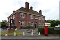
The Jubilee Inn, Cannock
Showing position of Postbox No. WS11 276.
See Image] for postbox.
Image: © JThomas
Taken: 18 May 2019
0.22 miles
8
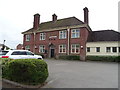
The Jubilee Inn, Hednesford, Cannock
On Pye Green Road.
Image: © JThomas
Taken: 18 May 2019
0.23 miles