
IMAGES TAKEN NEAR TO
Simcox Street, CANNOCK, WS12 1BG
Introduction
This page details the photographs taken nearby to Simcox Street, WS12 1BG by members of the Geograph project.
The Geograph project started in 2005 with the aim of publishing, organising and preserving representative images for every square kilometre of Great Britain, Ireland and the Isle of Man.

There are currently over 7.5m images from over14,400 individuals and you can help contribute to the project by visiting https://www.geograph.org.uk
Image Map
Images are licensed for reuse under creativecommons.org/licenses/by-sa/2.0
Notes
- Clicking on the map will re-center to the selected point.
- The higher the marker number, the further away the image location is from the centre of the postcode.
Image Listing (5 Images Found)
Images are licensed for reuse under creativecommons.org/licenses/by-sa/2.0
Image
Details
Distance
1
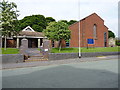
St Peter's Church, Hednesford
This is the building that gives rise to the name of Church Hill, which leads down to the town centre below.
Image: © Richard Law
Taken: 5 Jun 2013
0.08 miles
2
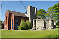
St Peter's Church, Hednesford
The church dates only from 1987, although the building it replaced was not ancient. The old church was built in 1868 on land donated by the Marquess of Anglesey; it suffered considerable subsidence damage and eventually had to be demolished - although part of the east end has been preserved and can be seen here.
Image: © Stephen McKay
Taken: 5 May 2017
0.08 miles
4
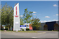
Anglesey Business Park
The Anglesey name crops up in several places around this part of Staffordshire, including this business park off Littleworth Road. The former seat of the Marquess of Anglesey was at Beaudesert on Cannock Chase.
Image: © Stephen McKay
Taken: 5 May 2017
0.22 miles
5
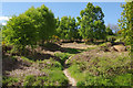
Hednesford Hills
The path leads on to the heathland from Littleworth Road.
Image: © Stephen McKay
Taken: 5 May 2017
0.24 miles