IMAGES TAKEN NEAR TO
Brownhills Road, CANNOCK, WS11 9TD
Introduction
This page details the photographs taken nearby to Brownhills Road, WS11 9TD by members of the Geograph project.
The Geograph project started in 2005 with the aim of publishing, organising and preserving representative images for every square kilometre of Great Britain, Ireland and the Isle of Man.

There are currently over 7.5m images from over14,400 individuals and you can help contribute to the project by visiting https://www.geograph.org.uk
Image Map
Images are licensed for reuse under creativecommons.org/licenses/by-sa/2.0
Notes
- Clicking on the map will re-center to the selected point.
- The higher the marker number, the further away the image location is from the centre of the postcode.
Image Listing (11 Images Found)
Images are licensed for reuse under creativecommons.org/licenses/by-sa/2.0
Image
Details
Distance

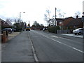
2
Looking East to Cross Roads, Norton Canes
Image: © Mick Malpass
Taken: 15 Jun 2011
0.03 miles
5
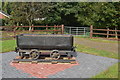
Colliery wagon
Norton Canes was at the centre of a coal mining district.
Image: © John M
Taken: 15 Oct 2013
0.05 miles
8
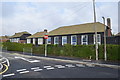
Timber buildings at Norton Canes Primary School
The school has been in 'Special Measures' since 2011. Consultations are ongoing for a change to Academy status.
Image: © John M
Taken: 15 Oct 2013
0.14 miles