IMAGES TAKEN NEAR TO
School Close, CANNOCK, WS11 9SH
Introduction
This page details the photographs taken nearby to School Close, WS11 9SH by members of the Geograph project.
The Geograph project started in 2005 with the aim of publishing, organising and preserving representative images for every square kilometre of Great Britain, Ireland and the Isle of Man.

There are currently over 7.5m images from over14,400 individuals and you can help contribute to the project by visiting https://www.geograph.org.uk
Image Map
Images are licensed for reuse under creativecommons.org/licenses/by-sa/2.0
Notes
- Clicking on the map will re-center to the selected point.
- The higher the marker number, the further away the image location is from the centre of the postcode.
Image Listing (10 Images Found)
Images are licensed for reuse under creativecommons.org/licenses/by-sa/2.0
Image
Details
Distance
1
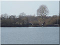
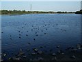
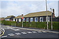
Houses in Norton East overlooking Norton Lakeside Wildfowl Reserve
The reserve is a northwesterly extension of the Chasewater canal reservoir. The houses to the left are in Norton East Road. The single-storey terrace is in School Road. A brook runs through Norton East into the reservoir: the road crossing can just be made out on the right.
Image: © Robin Stott
Taken: 8 Apr 2015
0.07 miles
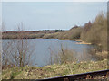
2
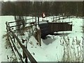
Jeffries Swag - Chasewater
The swag was created when the dam crest to the main reservoir was raised in the early 1900s.
Image: © John M
Taken: 15 Oct 2013
0.11 miles
3
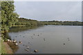
Norton Top Pool
This is the sluice gate that allows the over spill from the top pool to drain into Norton Bog, or Geoffreys Swag, as some people call it, not usually seen from this angle, walkers tend to lean over the handrail where the lifebuoy is, looking at this scene summer seems a lifetime away.
Image: © Bruce Kain
Taken: 13 Jan 2010
0.12 miles
4
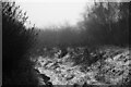
Tread Carefully
Ambient light landscape format image, of part of public footpath through a wood.
Rural public footpath leads ahead, curves left beyond the dark scrub to far left
The gradual banking in front to the right, follows the paths curve.
The surface of the ground is damp, sleet covered, hence the title.
Beyond the close growing copse, is one of the Chasewater Park areas of water.
Behind, is Norton East Road, Norton Canes.
Image: © D M Wilmot
Taken: 11 Dec 2022
0.16 miles
5
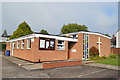
Timber buildings at Norton Canes Primary School
The school has been in 'Special Measures' since 2011. Consultations are ongoing for a change to Academy status.
Image: © John M
Taken: 15 Oct 2013
0.16 miles
6
Norton Lakeside Wildfowl Reserve, at the Norton East end of Chasewater
Image: © Robin Stott
Taken: 8 Apr 2015
0.22 miles