IMAGES TAKEN NEAR TO
Spode Place, CANNOCK, WS11 7YZ
Introduction
This page details the photographs taken nearby to Spode Place, WS11 7YZ by members of the Geograph project.
The Geograph project started in 2005 with the aim of publishing, organising and preserving representative images for every square kilometre of Great Britain, Ireland and the Isle of Man.

There are currently over 7.5m images from over14,400 individuals and you can help contribute to the project by visiting https://www.geograph.org.uk
Image Map
Images are licensed for reuse under creativecommons.org/licenses/by-sa/2.0
Notes
- Clicking on the map will re-center to the selected point.
- The higher the marker number, the further away the image location is from the centre of the postcode.
Image Listing (8 Images Found)
Images are licensed for reuse under creativecommons.org/licenses/by-sa/2.0
Image
Details
Distance
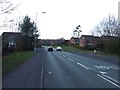
1
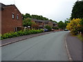
Houses on Attingham Drive in Hawks Green
Image: © Richard Law
Taken: 18 Jun 2013
0.03 miles
2
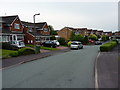
Houses on St Lawrence Drive in Hawks Green
Image: © Richard Law
Taken: 18 Jun 2013
0.08 miles
3
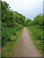
Path in the Nature Reserve
A network of tracks and paths pass through this Local Nature Reserve on the east side of Cannock. Much of the area is old coal-mining land.
Image: © Richard Law
Taken: 18 Jun 2013
0.11 miles
6
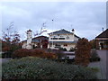
Winding Wheel Pub
The popular Winding Wheel pub near the District centre Heath Hayes
Image: © Graham Burnett
Taken: 14 Nov 2006
0.22 miles
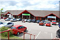
8

The Groom Room
Gents grooming emporium
Image: © Darrin Antrobus
Taken: 5 Feb 2013
0.23 miles