IMAGES TAKEN NEAR TO
Johnson Road, CANNOCK, WS11 4BB
Introduction
This page details the photographs taken nearby to Johnson Road, WS11 4BB by members of the Geograph project.
The Geograph project started in 2005 with the aim of publishing, organising and preserving representative images for every square kilometre of Great Britain, Ireland and the Isle of Man.

There are currently over 7.5m images from over14,400 individuals and you can help contribute to the project by visiting https://www.geograph.org.uk
Image Map
Images are licensed for reuse under creativecommons.org/licenses/by-sa/2.0
Notes
- Clicking on the map will re-center to the selected point.
- The higher the marker number, the further away the image location is from the centre of the postcode.
Image Listing (3 Images Found)
Images are licensed for reuse under creativecommons.org/licenses/by-sa/2.0
Image
Details
Distance
1
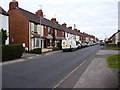
Cemetery Road, Broomhill
Victorian terraced housing on Cemetery Road.
Image: © Richard Law
Taken: 12 Sep 2014
0.19 miles
3
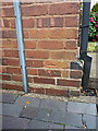
OS benchmark - Broomhill, 342 Cemetery Road
An OS cutmark on the side wall of 342 Cemetery Road (at the junction with Cambria Street); originally levelled in 1963 at 178m above Ordnance Datum Newlyn.
Image: © Richard Law
Taken: 12 Sep 2014
0.21 miles