IMAGES TAKEN NEAR TO
Watling Street, CANNOCK, WS11 1SH
Introduction
This page details the photographs taken nearby to Watling Street, WS11 1SH by members of the Geograph project.
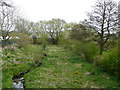
The Geograph project started in 2005 with the aim of publishing, organising and preserving representative images for every square kilometre of Great Britain, Ireland and the Isle of Man.

There are currently over 7.5m images from over14,400 individuals and you can help contribute to the project by visiting https://www.geograph.org.uk
Image Map
Images are licensed for reuse under creativecommons.org/licenses/by-sa/2.0
Notes
- Clicking on the map will re-center to the selected point.
- The higher the marker number, the further away the image location is from the centre of the postcode.
Image Listing (15 Images Found)
Images are licensed for reuse under creativecommons.org/licenses/by-sa/2.0
Image
Details
Distance
1
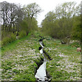
Hatherton Canal, near Wedges Mills, Staffordshire
The water is barely a trickle here, as a couple of hundred metres eastward it has been filled in. Extensive vegetation is growing on the silted up canal because the lock 400 metres westwards has no gates so the pound has drained; it should be up to about a metre deeper. Restoration of this canal, and the Lichfield Canal will allow navigation again between the Staffordshire and Worcestershire and Coventry Canals. See http://www.lhcrt.org.uk
Image: © Roger D Kidd
Taken: 26 Apr 2008
0.11 miles
2
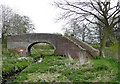
Bridge 7, Hatherton Canal, Wedges Mills, Staffordshire
Image: © Roger D Kidd
Taken: 26 Apr 2008
0.12 miles
3
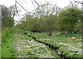
Hatherton Canal near Wedges Mills, Staffordshire
The water is barely a trickle here, as a couple of hundred metres eastward it has been filled in. Extensive vegetation is growing on the silted up canal because the lock 400 metres westwards has no gates so the pound has drained; it should be up to about a metre deeper. Restoration of this canal, and the Lichfield Canal will allow navigation again between the Staffordshire and Worcestershire and Coventry Canals. See http://www.lhcrt.org.uk
Image: © Roger D Kidd
Taken: 26 Apr 2008
0.13 miles
4
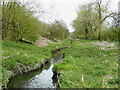
Hatherton Canal, towards Wedges Mills, Staffordshire
The water is about two metres wide here, flanked by extensive vegetation growing on the silted up canal. As the lock 250 metres westwards has no gates, the pound has drained; it should be up to about a metre deeper.
Image: © Roger D Kidd
Taken: 26 Apr 2008
0.14 miles
5
Hatherton Canal near Wedges Mills, Staffordshire
Looking east from the bridge at SJ96450901, about 100 metres away the canal has been filled in though the route is still recoverable.
Image: © Roger D Kidd
Taken: 26 Apr 2008
0.14 miles
7
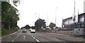
Longford Island, Cannock
A very busy island where the A5 crosses the Wolverhampton to Cannock Road. The Longford House pub/restaurant is in the background.
Image: © Geoff Pick
Taken: 24 Jul 2006
0.18 miles
8
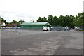
A5 approaching A4601 roundabout
Premier Inn Cannock on the left, DFS store on right
Image: © John Firth
Taken: 9 Jun 2013
0.19 miles
9
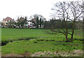
Meadows, Wedges Mills, Staffordshire
The Saredon Brook flows westwards, from left to right.
Image: © Roger D Kidd
Taken: 26 Apr 2008
0.20 miles
10
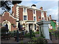
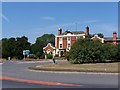
Longford House hotel
A landmark building on the way along Watling Street in Cannock, which has given its name to the roundabout where the A5 and A460 cross. It trades with both a Beefeater restaurant at front of house, and a Premier Inn at the rear.
Image: © Richard Law
Taken: 13 Aug 2014
0.22 miles