IMAGES TAKEN NEAR TO
Delville Close, WEDNESBURY, WS10 9EF
Introduction
This page details the photographs taken nearby to Delville Close, WS10 9EF by members of the Geograph project.
The Geograph project started in 2005 with the aim of publishing, organising and preserving representative images for every square kilometre of Great Britain, Ireland and the Isle of Man.

There are currently over 7.5m images from over14,400 individuals and you can help contribute to the project by visiting https://www.geograph.org.uk
Image Map
Images are licensed for reuse under creativecommons.org/licenses/by-sa/2.0
Notes
- Clicking on the map will re-center to the selected point.
- The higher the marker number, the further away the image location is from the centre of the postcode.
Image Listing (10 Images Found)
Images are licensed for reuse under creativecommons.org/licenses/by-sa/2.0
Image
Details
Distance
1
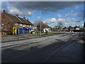
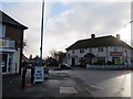
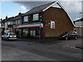
Shops on Manor House Road
A small parade of shops & a bookie, at the junction with Hawthorn Road and Hobs Road.
Image: © Richard Law
Taken: 19 Feb 2012
0.04 miles
3
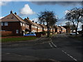
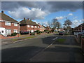
At the junction of Hawthorn Road and Ash Avenue, Kings Hill
Image: © Richard Law
Taken: 19 Feb 2012
0.13 miles
5
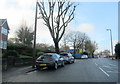
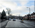
B4200 Manor House Road Wednesbury Approaching St Marys RC Primary School
Image: © Roy Hughes
Taken: 18 Dec 2017
0.19 miles
7
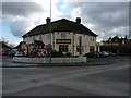
The Myvod
The public house sits at the junction of Myvod Road and Park Lane in Wood Green.
Image: © Richard Law
Taken: 19 Feb 2012
0.24 miles
9
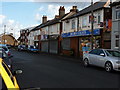
Spar shop on Hobs Road
At the junction with Parkdale Avenue.
Image: © Richard Law
Taken: 19 Feb 2012
0.24 miles
10
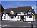
Leathern Bottel
The 1510 Pub in Vicarage Road, Wednesbury.
Image: © Gordon Griffiths
Taken: 21 Apr 2009
0.25 miles