IMAGES TAKEN NEAR TO
Addison Street, WEDNESBURY, WS10 9AW
Introduction
This page details the photographs taken nearby to Addison Street, WS10 9AW by members of the Geograph project.
The Geograph project started in 2005 with the aim of publishing, organising and preserving representative images for every square kilometre of Great Britain, Ireland and the Isle of Man.

There are currently over 7.5m images from over14,400 individuals and you can help contribute to the project by visiting https://www.geograph.org.uk
Image Map
Images are licensed for reuse under creativecommons.org/licenses/by-sa/2.0
Notes
- Clicking on the map will re-center to the selected point.
- The higher the marker number, the further away the image location is from the centre of the postcode.
Image Listing (40 Images Found)
Images are licensed for reuse under creativecommons.org/licenses/by-sa/2.0
Image
Details
Distance
1
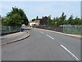
Ridding Lane crosses the railway
At the southern end of Ridding Lane, the bridge carries the road across the former South Staffs Railway line between Dudley and Walsall. The line opened in 1850, and closed to passengers in the 1960s and then to goods in 1993.
Image: © Richard Law
Taken: 26 Jul 2012
0.07 miles
2
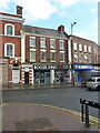
31 & 33 Market Place, Wednesbury
The 'Booze King' shop occupies a pair of late 18th century town houses which were Grade II listed https://britishlistedbuildings.co.uk/101287437-31-and-33-market-place-wednesbury-south-ward#.YXGUahrMLIU & https://historicengland.org.uk/listing/the-list/list-entry/1287437 in 1950.
Image: © Richard Law
Taken: 20 Oct 2021
0.10 miles
3
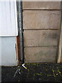
OS benchmark - Wednesbury, 30 Lower High Street
The OS cutmark lies on one of the quoin stones of the one-time bank in the market place, and was last levelled in 1956 at 139.150m above Ordnance Datum Newlyn. The building appears to be empty at present (Oct 2021)
Image: © Richard Law
Taken: 20 Oct 2021
0.10 miles
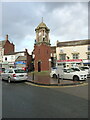
4

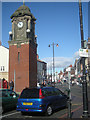
Wednesbury Clock Tower
This attractive red brick and sandstone structure was unveiled during 1911 in recognition of the coronation of George V.Wednesbury Clock Tower is grade II listed.
Image: © Stephen Rogerson
Taken: 29 Sep 2011
0.11 miles
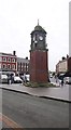
6
Wednesbury Clock Tower
Built in 1911 to celebrate the coronation of George V, and constructed of sandstone and red brick, with carvings in a Baroque style. It was Grade II listed https://britishlistedbuildings.co.uk/101077119-clock-tower-in-wednesbury-market-place-wednesbury-south-ward#.YXGR7RrMLIU & https://historicengland.org.uk/listing/the-list/list-entry/1077119 in 1987.
Image: © Richard Law
Taken: 20 Oct 2021
0.12 miles
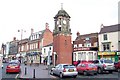
7
Wednesbury, clock tower
On Market Place; according to a plaque, erected to commemorate King George V's coronation in 1911.
Image: © Mike Faherty
Taken: 29 Jun 2013
0.12 miles
9

Former bingo hall, Walsall Street, Wednesbury
The legend "WALKERS BINGO CLUB" can just be picked out above the entrance.
Image: © Richard Vince
Taken: 27 Dec 2017
0.16 miles
10
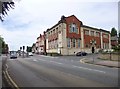
Wednesbury Library
On Walsall Street, at the corner of Hollies Drive, with a foundation stone of 1907: http://www.sandwell.gov.uk/info/200261/libraries/829/wednesbury_library
Image: © Mike Faherty
Taken: 29 Jun 2013
0.16 miles