
IMAGES TAKEN NEAR TO
Upper High Street, WEDNESBURY, WS10 7HL
Introduction
This page details the photographs taken nearby to Upper High Street, WS10 7HL by members of the Geograph project.
The Geograph project started in 2005 with the aim of publishing, organising and preserving representative images for every square kilometre of Great Britain, Ireland and the Isle of Man.

There are currently over 7.5m images from over14,400 individuals and you can help contribute to the project by visiting https://www.geograph.org.uk
Image Map
Images are licensed for reuse under creativecommons.org/licenses/by-sa/2.0
Notes
- Clicking on the map will re-center to the selected point.
- The higher the marker number, the further away the image location is from the centre of the postcode.
Image Listing (66 Images Found)
Images are licensed for reuse under creativecommons.org/licenses/by-sa/2.0
Image
Details
Distance

2

Bottom of Church Hill, Wednesbury
Seen from Walsall Street. This section is severed from the rest of Church Hill by High Bullen, a section of the A461 that forms an inner bypass around the north west corner of Wednesbury town centre. However, the spire of the church after which the street was presumably named can still be seen from here.
Image: © Richard Vince
Taken: 27 Dec 2017
0.05 miles

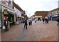
5

OS benchmark - Wednesbury, 2 Union Street
An early OS cutmark on the wall of no 2 Union Street, last levelled in 1956 at 140.860m above Ordnance Datum Newlyn. It also appears on early maps at a height of 462.21ft above Newlyn Datum, based on the 1st Primary Levelling in the period 1912-1921.
Image: © Richard Law
Taken: 20 Oct 2021
0.06 miles
6
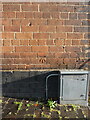
OS benchmark - Wednesbury, shop on Walsall Street
The shop is described in the OS database as Boots Chemist, but that appears to be no longer the case. The mark was last levelled in 1956 at 141.888m above Ordnance Datum Newlyn, and appears on older maps at 465.56ft Liverpool Datum. It was probably cut as part of the 1st Primary Levelling survey in 1843/44 at which point it was documented as "Mr Anslow's Grocery Shop"
Image: © Richard Law
Taken: 20 Oct 2021
0.06 miles
7
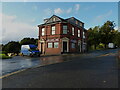
The Woden Inn, Wednesbury
Despite the writing on the blackboard in the original central doorway which proudly proclaims "Disco, Saturday", there appeared to be significant rebuilding work underway, and I rather suspect it's not currently open or trading as a public house. Happy to be corrected on that front.
Image: © Richard Law
Taken: 20 Oct 2021
0.06 miles
8
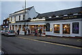
The Bellwether Public House
Wetherspoons pub on Walsall Street, Wednesbury.
Image: © Ian S
Taken: 16 Dec 2021
0.07 miles
9

Walsall Street, Wednesbury
One way at this point, from the A461 to Upper High Street.
Image: © Richard Vince
Taken: 27 Dec 2017
0.07 miles
10

Union Street
A pedestrian street which has lights that look like old gas lights.
Image: © Stephen Rogerson
Taken: 29 Sep 2011
0.07 miles