
IMAGES TAKEN NEAR TO
Victoria Street, WEDNESBURY, WS10 7EH
Introduction
This page details the photographs taken nearby to Victoria Street, WS10 7EH by members of the Geograph project.
The Geograph project started in 2005 with the aim of publishing, organising and preserving representative images for every square kilometre of Great Britain, Ireland and the Isle of Man.

There are currently over 7.5m images from over14,400 individuals and you can help contribute to the project by visiting https://www.geograph.org.uk
Image Map
Images are licensed for reuse under creativecommons.org/licenses/by-sa/2.0
Notes
- Clicking on the map will re-center to the selected point.
- The higher the marker number, the further away the image location is from the centre of the postcode.
Image Listing (63 Images Found)
Images are licensed for reuse under creativecommons.org/licenses/by-sa/2.0
Image
Details
Distance

2

Wednesbury Museum and Art Gallery
Wednesbury Museum is Sandwell's Museum and Art Gallery. It is purpose built Victorian Art Gallery, housing collections which include fine art paintings, applied art, old toys as well as one of the world's largest collections of Ruskin pottery.
Image: © Stephen Rogerson
Taken: 29 Sep 2011
0.03 miles
3
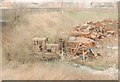
Old LNWR goods yard at Wednesbury
This is the old goods yard operated by the LNWR at Wednesbury. I have a 1975 picture of this yard in Ned Williams's book "Railways of the Black Country" which shows these two little diesel locos parked up in exactly the same place! After the yard closed to railway freight traffic, it was operated as a scrap yard by R A Giblin; this picture shows the site just before it was cleared.
Image: © John Winder
Taken: Unknown
0.05 miles
4
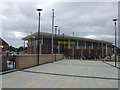
Morrisons, Wednesbury
The supermarket opened in November 2007 being built on the site of the Union Centre later known as the 'Wednesbury Shopping Hall'. Wednesbury was on the A41 Holyhead Road between Birmingham and Wolverhampton but is now bypassed by traffic using the Black Country Spine Road.
Image: © John M
Taken: 28 Jun 2008
0.06 miles
5

LNWR goods shed, Wednesbury
The old London & North Western Railway goods shed near what used to be Wednesbury Town station (see http://www.geograph.org.uk/photo/2678913). I visited this site in 1993 and at that time the yard was heavily overgrown and contained, among a lot of other scrap, two tiny diesel shunters standing on the remains of a siding roughly where the red car bumper is in this shot. Later on, I drove a truck for a haulage company based in this yard ... I had a good look around but sadly all trace of the railway had disappeared. The building was still in good condition though, as was the rail overbridge I'm standing on to take this shot, even though it had been infilled on one side.
Image: © John Winder
Taken: 8 May 2008
0.06 miles
6
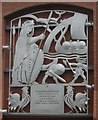
The beginnings of Wednesbury
King Alfred's eldest daughter Ethelfleda - Lady of the Mercians (869-918) is believed to have fortified Church Hill to repel the invading Vikings.
Image: © John M
Taken: 28 Jun 2008
0.06 miles
7

'Each footprint marks a step in time'
Mosaic between the town centre and the bus station. Image
Image: © John M
Taken: 28 Jun 2008
0.06 miles
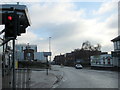
9
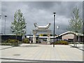
Wednesbury Bus Station
The new bus station with ten bus stands and electronic departure information system was completed in November 2004.
Image: © John M
Taken: 28 Jun 2008
0.07 miles
10
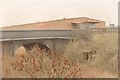
Old railway bridge at Wednesbury goods yard
This bridge - still there today but now infilled from the far side - carried Victoria Street over the line from Wednesbury Town to Darlaston. Originally a passenger service operated over the line, but this lasted only until 1887, after which date the line was used solely for freight traffic. It mostly served Patent Shaft steelworks which were near here.
I worked for a while for a road haulage company which was based in the old goods yard and shed, and this bridge was used as our garage!
Image: © John Winder
Taken: Unknown
0.07 miles