IMAGES TAKEN NEAR TO
Holloway Bank, WEDNESBURY, WS10 0PA
Introduction
This page details the photographs taken nearby to Holloway Bank, WS10 0PA by members of the Geograph project.
The Geograph project started in 2005 with the aim of publishing, organising and preserving representative images for every square kilometre of Great Britain, Ireland and the Isle of Man.

There are currently over 7.5m images from over14,400 individuals and you can help contribute to the project by visiting https://www.geograph.org.uk
Image Map
Images are licensed for reuse under creativecommons.org/licenses/by-sa/2.0
Notes
- Clicking on the map will re-center to the selected point.
- The higher the marker number, the further away the image location is from the centre of the postcode.
Image Listing (33 Images Found)
Images are licensed for reuse under creativecommons.org/licenses/by-sa/2.0
Image
Details
Distance
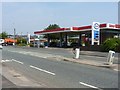
6
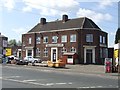
Fountain Inn
No longer in use but the car park has a hand car wash and fencing sales operation.
Image: © John M
Taken: 16 Apr 2011
0.10 miles
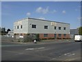
7
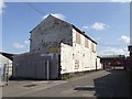
Factory unit - Rigby Street
Typical Black Country workshop building now surrounded by small industrial estate.
Image: © John M
Taken: 16 Apr 2011
0.10 miles