
IMAGES TAKEN NEAR TO
Bassett Road, WEDNESBURY, WS10 0HN
Introduction
This page details the photographs taken nearby to Bassett Road, WS10 0HN by members of the Geograph project.
The Geograph project started in 2005 with the aim of publishing, organising and preserving representative images for every square kilometre of Great Britain, Ireland and the Isle of Man.

There are currently over 7.5m images from over14,400 individuals and you can help contribute to the project by visiting https://www.geograph.org.uk
Image Map
Images are licensed for reuse under creativecommons.org/licenses/by-sa/2.0
Notes
- Clicking on the map will re-center to the selected point.
- The higher the marker number, the further away the image location is from the centre of the postcode.
Image Listing (7 Images Found)
Images are licensed for reuse under creativecommons.org/licenses/by-sa/2.0
Image
Details
Distance
2
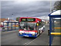
Bus in Friar Park (1)
The 410 is the main bus route serving Friar Park, going to Wednesbury in one direction and West Bromwich via Stone Cross in the other. The timing point in Friar Park is in a rather odd two way bus only road, which is arranged to enable buses to travel through in either direction, or to turn round by circumnavigating a small green. This bus is going through on its way from West Bromwich to Wednesbury; the bus stop on the opposite side is used by buses going the other way. In the background on the left is a supermarket, which (if dim and distant memory serves) was built on the site of a large pub called the Coronation, whose name the bus stops once bore.
Image: © Richard Vince
Taken: 5 Oct 2011
0.13 miles
3
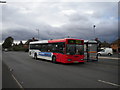
Bus in Friar Park (2)
A 410 to West Bromwich sits at the eastbound bus stop in the bus only road in Friar Park (see Image for a view facing the other way). The small white van is in the car park of the supermarket just out of frame to the right.
Image: © Richard Vince
Taken: 5 Oct 2011
0.13 miles
4
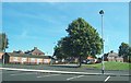
The View from Lidl
Crankhall Lane, West Bromwich.
Image: © Adrian Bailey
Taken: 21 Aug 2005
0.14 miles
5
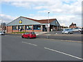
Lidl store on Manor Road
At the junction of Manor Road and Crankhall Lane in Friar Park.
Image: © Richard Law
Taken: 19 Apr 2013
0.14 miles
6
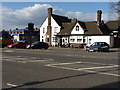
The Friar Park
A public house on Crankhall Lane in Friar Park village.
Image: © Richard Law
Taken: 19 Apr 2013
0.16 miles
7
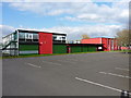
Parking area at the Phoenix Collegiate
The Phoenix Collegiate is a new school, formed in 2010 after the closure and merger of two former schools in Sandwell, the Manor (on this site) and the Menzies.
Image: © Richard Law
Taken: 19 Apr 2013
0.19 miles