IMAGES TAKEN NEAR TO
Blackfriars Avenue, DROITWICH, WR9 8RX
Introduction
This page details the photographs taken nearby to Blackfriars Avenue, WR9 8RX by members of the Geograph project.
The Geograph project started in 2005 with the aim of publishing, organising and preserving representative images for every square kilometre of Great Britain, Ireland and the Isle of Man.

There are currently over 7.5m images from over14,400 individuals and you can help contribute to the project by visiting https://www.geograph.org.uk
Image Map
Images are licensed for reuse under creativecommons.org/licenses/by-sa/2.0
Notes
- Clicking on the map will re-center to the selected point.
- The higher the marker number, the further away the image location is from the centre of the postcode.
Image Listing (246 Images Found)
Images are licensed for reuse under creativecommons.org/licenses/by-sa/2.0
Image
Details
Distance
1
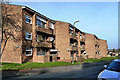
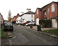
Blackfriars Court
New housing development in Droitwich Spa, near the junction of Blackfriars Avenue and Spa Road.
Image: © Mary and Angus Hogg
Taken: 6 Dec 2012
0.01 miles
2
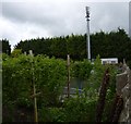
Communications mast in Dorset House gardens
Droitwich Spa
Image: © Jeff Gogarty
Taken: 3 May 2015
0.04 miles
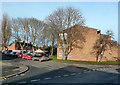
3
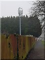
Communication mast by the Saltway, Droitwich
The transmitting equipment has had been updated since Image was taken.
Image: © Jeff Gogarty
Taken: 21 Jan 2023
0.04 miles
4
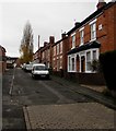
Change in road surface, Miller Street, Droitwich
The nameplate on the wall at first floor level on the right shows GLENLYN HOUSE.
Image: © Jaggery
Taken: 16 Nov 2016
0.04 miles
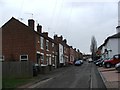
5
Up Miller Street, Droitwich
Miller Street ascends southwards towards Manning Road and Spa Road.
Image: © Jaggery
Taken: 16 Nov 2016
0.04 miles
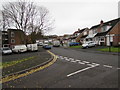
6
Spa Road, Droitwich
The junction of Blackfriars Avenue and Spa Road, leading to Manning Road.
Image: © Mary and Angus Hogg
Taken: 6 Dec 2012
0.05 miles
7
Junction at the southern end of Miller Street, Droitwich
Viewed from Miller Street. Spa Road is on the left, Manning Road out of shot on the right.
Image: © Jaggery
Taken: 16 Nov 2016
0.05 miles
8
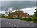
Artillery House, Droitwich
Artillery House is a self-contained office extending to 16,658 sq ft in the centre of Droitwich. The property is fully let to the Crown Prosecution Service. It is currently (September 2016) being used by Balfour Beatty Ltd as the control centre for the modifying of the M5 into a smart motorway.
Image: © Jeff Gogarty
Taken: 3 May 2015
0.05 miles
10

South along Burrish Street, Droitwich
Towards Manning Road from near these http://www.geograph.org.uk/photo/5202076 posts.
Image: © Jaggery
Taken: 16 Nov 2016
0.07 miles