IMAGES TAKEN NEAR TO
St. Augustine Drive, DROITWICH, WR9 8QR
Introduction
This page details the photographs taken nearby to St. Augustine Drive, WR9 8QR by members of the Geograph project.
The Geograph project started in 2005 with the aim of publishing, organising and preserving representative images for every square kilometre of Great Britain, Ireland and the Isle of Man.

There are currently over 7.5m images from over14,400 individuals and you can help contribute to the project by visiting https://www.geograph.org.uk
Image Map
Images are licensed for reuse under creativecommons.org/licenses/by-sa/2.0
Notes
- Clicking on the map will re-center to the selected point.
- The higher the marker number, the further away the image location is from the centre of the postcode.
Image Listing (243 Images Found)
Images are licensed for reuse under creativecommons.org/licenses/by-sa/2.0
Image
Details
Distance
1
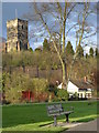
Hill Court, Droitwich
This large early 19th century stuccoed house is now part of Dodderhill School that is fee-paying. The house is Listed Grade II.
Image: © Chris Allen
Taken: 30 Apr 2022
0.06 miles
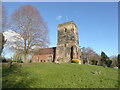
2
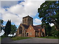
St Augustines Church, Dodderhill, Droitwich Spa
This picture of St Augustines, "The Church on the hill", is taken from the car-park opposite. Work started on the Norman Church around 1180 AD, the building being completed around 1220AD. The crossing and north transept are the only parts of the current building to date from this time. Its prominent position over looking Droitwich made it the dominant church in the area. During the Civil War this almost became its downfall. In 1646AD Parliamentarians were billeted in it, and during the Royalist attack the church was fired, exploding armaments destroyed the nave and south transept, severely damaging the rest of the building.
In the early 18th century, the tower and south transept were rebuilt using the masonry from the damaged building. The tower was now located over, and as part of, the south transept. The building retains this extremely unusual T-shape and positioning of the tower today.
In the late 20th Century a further change was made to the layout and a new extension built containing kitchen and toilet facilities.
Image: © Charles Ross
Taken: 4 Nov 2006
0.06 miles
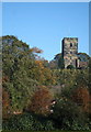
5
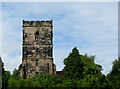
The tower of St Augustine's Church near Droitwich
The tower of St Augustine's at Dodderhill was rebuilt in the early 18th century, but the church has a history going back many more centuries. http://www.droitwichparish.org.uk/about/augustine.html http://www.geograph.org.uk/photo/485056
Image: © Roger D Kidd
Taken: 22 Aug 2010
0.08 miles
6
Hillside with church tower in Droitwich, Worcestershire
Seen with telephoto assistance in late evening sunlight from 390 metres distance.
The tower of St Augustine's at Dodderhill was rebuilt in the early 18th century, but the church has a history going back many more centuries. http://www.droitwichparish.org.uk/about/augustine.html http://www.geograph.org.uk/photo/485056
Image: © Roger D Kidd
Taken: 21 Jun 2013
0.09 miles
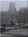
7
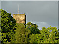
St Augustine Church of England church, Dodderhill, Droitwich
On a hill overlooking the town centre and visible from a fair distance. Only the second time I had been here since 1977 and the first time with a camera. This counted as lockdown exercise after a visit to the dentist in Droitwich.
Image: © Chris Allen
Taken: 10 Feb 2021
0.09 miles
8
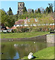
Droitwich Junction Canal in Droitwich Spa
With the backdrop of St Augustine's Church.
Image: © Mat Fascione
Taken: 19 Apr 2021
0.09 miles
9
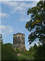
The tower of St Augustine's Church in Droitwich, Worcestershire
The Church of St Augustine was built between AD 1180 and AD 1220, and partly rebuilt in the early 18th century.
Image: © Roger D Kidd
Taken: 21 Aug 2010
0.10 miles