IMAGES TAKEN NEAR TO
The Holloway, DROITWICH, WR9 8HD
Introduction
This page details the photographs taken nearby to The Holloway, WR9 8HD by members of the Geograph project.
The Geograph project started in 2005 with the aim of publishing, organising and preserving representative images for every square kilometre of Great Britain, Ireland and the Isle of Man.

There are currently over 7.5m images from over14,400 individuals and you can help contribute to the project by visiting https://www.geograph.org.uk
Image Map
Images are licensed for reuse under creativecommons.org/licenses/by-sa/2.0
Notes
- Clicking on the map will re-center to the selected point.
- The higher the marker number, the further away the image location is from the centre of the postcode.
Image Listing (475 Images Found)
Images are licensed for reuse under creativecommons.org/licenses/by-sa/2.0
Image
Details
Distance
1
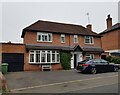
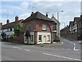
5 The Holloway, Droitwich Spa
This used to be a general store at least up to 2001 when the owner complained of too many roadworks in the road.
Image: © Jeff Gogarty
Taken: 8 Oct 2021
0.00 miles
2
Ring O' Bells, Droitwich
Pub at 7 The Holloway. http://www.geograph.org.uk/photo/5196360 to the name sign
Image: © Jaggery
Taken: 16 Nov 2016
0.01 miles
3
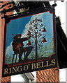
Ring O' Bells name sign, Droitwich
Hanging from a wall bracket here. http://www.geograph.org.uk/photo/5196358
Image: © Jaggery
Taken: 16 Nov 2016
0.01 miles
4
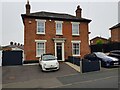
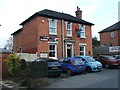
7 The Holloway, Droitwich Spa
Presently a semi-detached house this was formally the Ring O'Bells Image which is still marked in the glass above the door.
Image: © Jeff Gogarty
Taken: 8 Oct 2021
0.01 miles
5
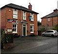
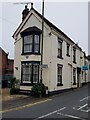
The Toll House
Located at the junction of the road known as The Holloway, with Hanbury Street and Hanbury Road. The building is thought to date from around 1800. It is now a private residence.
Image: © P L Chadwick
Taken: 15 Jun 2010
0.01 miles
7
1, The Holloway, Droitwich Spa
Recent research has shown the old Toll Road used to go to the left of where this house is so to the right of Image
Image: © Jeff Gogarty
Taken: 8 Oct 2021
0.01 miles
8
Eight green shutters, The Holloway, Droitwich
On the west side of The Holloway. The plaque http://www.geograph.org.uk/photo/5196743 on the left is on the wall of Coventry Hospital almshouses.
Image: © Jaggery
Taken: 16 Nov 2016
0.02 miles
9
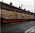
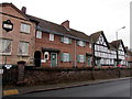
Coventry Hospital, Droitwich
Viewed across The Holloway, Coventry Hospital is a Grade II listed row of almshouses built in the 17th century. This was a hospital in the medieval sense of a charitable institution for the housing and maintenance of the needy.
A plaque http://www.geograph.org.uk/photo/5196743 on the building shows Founded by The Right Honorable Henry Coventry, son of the Right Honorable Thomas, Lord Coventry, Lord Keeper of the Great Seal of England in the Reign of King Charles the First.
I don't know the date of the plaque, but the use of what is now the standard American spelling honorable for honourable is interesting.
Image: © Jaggery
Taken: 16 Nov 2016
0.02 miles
10
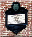
Coventry Hospital plaque, Droitwich
On the wall on the right side of this http://www.geograph.org.uk/photo/5196736 building.
Image: © Jaggery
Taken: 16 Nov 2016
0.02 miles