IMAGES TAKEN NEAR TO
Dormouse Fields, DROITWICH, WR9 7FS
Introduction
This page details the photographs taken nearby to Dormouse Fields, WR9 7FS by members of the Geograph project.
The Geograph project started in 2005 with the aim of publishing, organising and preserving representative images for every square kilometre of Great Britain, Ireland and the Isle of Man.

There are currently over 7.5m images from over14,400 individuals and you can help contribute to the project by visiting https://www.geograph.org.uk
Image Map
Images are licensed for reuse under creativecommons.org/licenses/by-sa/2.0
Notes
- Clicking on the map will re-center to the selected point.
- The higher the marker number, the further away the image location is from the centre of the postcode.
Image Listing (28 Images Found)
Images are licensed for reuse under creativecommons.org/licenses/by-sa/2.0
Image
Details
Distance
1
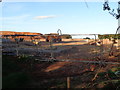
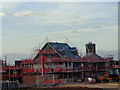
Development off Newlands Road, Droitwich
Image: © Jeff Gogarty
Taken: 31 Aug 2016
0.08 miles
3
Future "Mixed use area", whatever that means
Land on Yew Tree Hill on the edge of Droitwich Spa, Worcestershire that is going to be redeveloped as Yew Tree Village. http://www.barberry.co.uk/strategic-land/yew-tree-village-droitwich/
Image: © Jeff Gogarty
Taken: 5 Apr 2016
0.12 miles
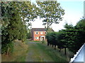
4
Footpath to Water Tower from Tagwell Open Space, Droitwich
Believe this is going to be tarmacked as part of the Yew Tree Village development. http://www.barberry.co.uk/strategic-land/yew-tree-village-droitwich/
Image: © Jeff Gogarty
Taken: 5 Apr 2016
0.12 miles
5
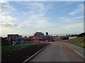
House building with Droitwich Water Tower
The Yew Tree Hill development will cover most of the area around the water tower.
Image: © Jeff Gogarty
Taken: 31 Aug 2016
0.14 miles
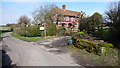
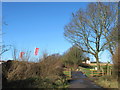
6
House on upper part of Newland Road, Droitwich
This section of Newland Road is separated from the main part due to a restricted section, currently open to only cyclists and pedestrians, as it climbs Yew Tree Hill. This area is currently being redeveloped.
Newland Road is part of National Cycle Route 45.
Image: © Jeff Gogarty
Taken: 31 Aug 2016
0.16 miles
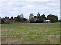
7
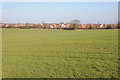
Urban boundary
The boundary between farmland and the southern periphery of Droitwich.
Image: © Philip Halling
Taken: 15 Jan 2012
0.17 miles
8
Newland Road Droitwich Closed For Building Work
Image: © Roy Hughes
Taken: 9 Feb 2018
0.17 miles
9
Development on Yew Tree Hill, Droitwich
Image: © Jeff Gogarty
Taken: 31 Aug 2016
0.17 miles
10

Shops on Yew Tree Village estate, Droitwich Spa
Image: © Jeff Gogarty
Taken: 17 Mar 2023
0.17 miles