IMAGES TAKEN NEAR TO
Upper Goosehill, DROITWICH, WR9 7ED
Introduction
This page details the photographs taken nearby to Upper Goosehill, WR9 7ED by members of the Geograph project.
The Geograph project started in 2005 with the aim of publishing, organising and preserving representative images for every square kilometre of Great Britain, Ireland and the Isle of Man.

There are currently over 7.5m images from over14,400 individuals and you can help contribute to the project by visiting https://www.geograph.org.uk
Image Map
Images are licensed for reuse under creativecommons.org/licenses/by-sa/2.0
Notes
- Clicking on the map will re-center to the selected point.
- The higher the marker number, the further away the image location is from the centre of the postcode.
Image Listing (15 Images Found)
Images are licensed for reuse under creativecommons.org/licenses/by-sa/2.0
Image
Details
Distance
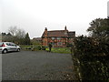
2
Upper Goosehill House, Hanbury, Worcestershire
The house, dating from the 17th century, is part of the Upper Goosehill Farm complex.
Image: © Jeff Gogarty
Taken: 24 Dec 2017
0.01 miles
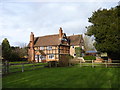
3
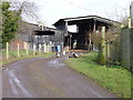
Converted Barns at Upper Goosehill Farm
Image: © Jeff Gogarty
Taken: 24 Dec 2017
0.02 miles
4
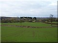
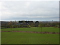
Upper Goosehill Farm from Madam's Hill
Near Broughton Green (in the Parish of Hanbury).
Image: © Jeff Gogarty
Taken: 24 Dec 2017
0.04 miles
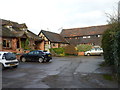
6
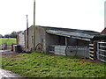
Farm buildings at Upper Goosehill Farm
Image: © Jeff Gogarty
Taken: 24 Dec 2017
0.06 miles
7
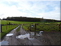
Track from Upper Goosehill Farm to Goosehill woods
The footpath around the farm is through the gate on the right.
Image: © Jeff Gogarty
Taken: 24 Dec 2017
0.08 miles
8
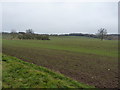
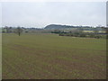
Footpath across the field towards Puck Hill
Another field of cloying Worcestershire mud - by the time you've walked a hundred yards of this stuff, there's a couple of pounds extra weight attached to each boot.
Image: © Richard Law
Taken: 14 Dec 2010
0.14 miles
9
Goosehill Farm with Droitwich water tower
Image: © Jeff Gogarty
Taken: 24 Dec 2017
0.14 miles
10
Footpath from Puck Hill towards Harding's Knapp
It's not visible on the ground at this early stage of crop growth, but there is definitely a footpath across here.
Image: © Richard Law
Taken: 14 Dec 2010
0.15 miles