
IMAGES TAKEN NEAR TO
The Holloway, DROITWICH, WR9 7AH
Introduction
This page details the photographs taken nearby to The Holloway, WR9 7AH by members of the Geograph project.
The Geograph project started in 2005 with the aim of publishing, organising and preserving representative images for every square kilometre of Great Britain, Ireland and the Isle of Man.

There are currently over 7.5m images from over14,400 individuals and you can help contribute to the project by visiting https://www.geograph.org.uk
Image Map
Images are licensed for reuse under creativecommons.org/licenses/by-sa/2.0
Notes
- Clicking on the map will re-center to the selected point.
- The higher the marker number, the further away the image location is from the centre of the postcode.
Image Listing (94 Images Found)
Images are licensed for reuse under creativecommons.org/licenses/by-sa/2.0
Image
Details
Distance
1
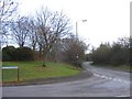
Cockshute Hill Junction with Tagwell Road.
Tagwell Road curves to the right to run alongside the M5 as it passes Droitwich.
Image: © Roy Hughes
Taken: 18 Jan 2009
0.07 miles
2

Tagwell Road, Droitwich
The trees on each side of the road screen local housing estates from the traffic noise.
Image: © David Smith
Taken: 22 May 2013
0.08 miles
3

Dovecote at St Peter's Manor, Droitwich
A 17th century dovecote with 750 nesting holes. Listed Grade II. Seen from a public path.
Image: © Chris Allen
Taken: 30 Apr 2022
0.08 miles
4
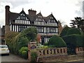
St Peter's Manor, Droitwich Spa, Worcestershire
Image: © Jeff Gogarty
Taken: 8 Nov 2022
0.08 miles
5
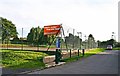
Droitwich Spa Lawn Tennis Club, St. Peter's Church Lane, Droitwich Spa, Worcs
This is the entrance to the club's grounds. There are eight courts here, of which one can be seen on the left. Four of these are all-weather and the other four are artificial grass. Four of the courts have floodlights for winter tennis. The club has a modern clubhouse opened in April 2004.
Image: © P L Chadwick
Taken: 6 Oct 2013
0.08 miles
6

Public footpath from St. Peter's Church Lane to Tagwell Road, Droitwich Spa, Worcs
In this direction this hard surfaced footpath is heading for Tagwell Road. It forms part of the Water Tower Walk.
Image: © P L Chadwick
Taken: 16 Aug 2015
0.08 miles
7

Path from Tagwell Road to St Peters church
Image: © Jeff Gogarty
Taken: 13 Nov 2020
0.08 miles
8

Information board by entrance to St. Peter's Fields, Droitwich Spa, Worcs
Located by the entrance from the public footpath running between Tagwell Road and St. Peter's Church Lane.
Image
Image: © P L Chadwick
Taken: 16 Aug 2015
0.08 miles
9

Entrance to St. Peter's Fields, Droitwich Spa, Worcs
One of many entrances to this public park. This one is off the public footpath running between Tagwell Road and St. Peter's Church Lane. By the entrance is a litter bin.
Image
Image: © P L Chadwick
Taken: 16 Aug 2015
0.08 miles
10
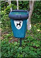
Dog waste bin by public footpath, Droitwich Spa, Worcs
It is located opposite one of the entrances to St. Peter's Fields, and by the side of the public footpath linking Tagwell Road and St. Peter's Church Lane. As both the fields (which are a public park) and the footpath are popular with dog walkers, this bin is in a strategic position! Unfortunately there remains a sizeable minority of dog walkers who fail to use the bins.
Image: © P L Chadwick
Taken: 16 Aug 2015
0.08 miles