IMAGES TAKEN NEAR TO
Sandford, WORCESTER, WR8 9JE
Introduction
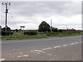
This page details the photographs taken nearby to Sandford, WR8 9JE by members of the Geograph project.
The Geograph project started in 2005 with the aim of publishing, organising and preserving representative images for every square kilometre of Great Britain, Ireland and the Isle of Man.

There are currently over 7.5m images from over14,400 individuals and you can help contribute to the project by visiting https://www.geograph.org.uk
Image Map (Loading...)


Getting Data...Please wait
Leaflet Map data © OpenStreetMap
Images are licensed for reuse under creativecommons.org/licenses/by-sa/2.0
Notes
- Clicking on the map will re-center to the selected point.
- The higher the marker number, the further away the image location is from the centre of the postcode.
Image Listing (36 Images Found)
Images are licensed for reuse under creativecommons.org/licenses/by-sa/2.0
Image
Details
Distance
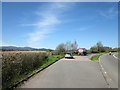
1
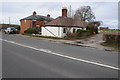
Cottages near the entrance to Sandford Villa Farm
At times of high flooding such as at present these cottages are vulnerable to floodwater hence the small floodbank in front of them.
Image: © Philip Halling
Taken: 9 Feb 2014
0.01 miles
2
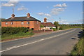
Houses beside the A38
Houses beside the A38 to the north of Severn Stoke.
Image: © Philip Halling
Taken: 23 Jun 2011
0.02 miles
3
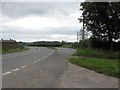
A38 at Sheepcote Farm lane junction
Parking lay-byes are provided on both sides of the curve, with an isolated letter box in the northbound one.
Image: © Peter Whatley
Taken: 27 Aug 2008
0.02 miles
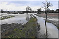
4
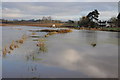
Flooding at Sandford Villa Farm
Flooding at Sandford Villa Farm viewed from the A38.
Image: © Philip Halling
Taken: 1 Dec 2012
0.04 miles
5
Sheepcote junction, A38
Sandford farm is across the road.
Image: © Peter Whatley
Taken: 27 Aug 2008
0.05 miles
6
Flooded farmland near Sandford
A small brook heads towards the River Severn from where the flooding is coming.
Image: © Bill Boaden
Taken: 15 Nov 2019
0.05 miles
7
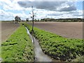
Drainage ditch through arable farmland
This land is part of the Severn floodplain and is regularly underwater. Image] Spring is here and this ditch is draining this arable farmland ready for this year's crops. A tractor is working in the distance.
Image: © Philip Halling
Taken: 29 Apr 2016
0.06 miles
8
Flooding at Sandford, Severn Stoke
Flooding at Sandford beside the A38 near Severn Stoke.
Image: © Philip Halling
Taken: 1 Dec 2012
0.06 miles
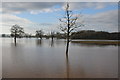
10
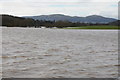
Flooding near Severn Stoke
View across the flooding near Severn Stoke to the northern end of the Malvern Hills.
Image: © Philip Halling
Taken: 9 Feb 2014
0.07 miles