IMAGES TAKEN NEAR TO
Rhydd, WORCESTER, WR8 0AE
Introduction
This page details the photographs taken nearby to Rhydd, WR8 0AE by members of the Geograph project.
The Geograph project started in 2005 with the aim of publishing, organising and preserving representative images for every square kilometre of Great Britain, Ireland and the Isle of Man.

There are currently over 7.5m images from over14,400 individuals and you can help contribute to the project by visiting https://www.geograph.org.uk
Image Map
Images are licensed for reuse under creativecommons.org/licenses/by-sa/2.0
Notes
- Clicking on the map will re-center to the selected point.
- The higher the marker number, the further away the image location is from the centre of the postcode.
Image Listing (10 Images Found)
Images are licensed for reuse under creativecommons.org/licenses/by-sa/2.0
Image
Details
Distance
1
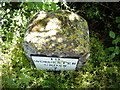
Bench mark on milestone
This nineteenth-century milestone is a Grade II listed structure and sits on the east side of the main road just north of Rhydd. The small indentation on top is the remains of an Ordnance Survey bench mark that possibly dates back to the First primary levelling of England & Wales in 1844. It was included on the Manchester to Gloucester levelling line, but appears to have been moved since then from a position shown on the 1884 map half a mile further south.
Image: © Shantavira
Taken: 21 Jun 2014
0.10 miles
2
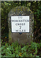
Old Milestone by the B4424, north of Rhydd, Guarlford parish
Metal plate attached to stone post by the B4424, in parish of GUARLFORD (MALVERN HILLS District), North of Rhydd, 200 yds South of drive to Dripshill House, on the verge, on East side of road. Worcester Cross iron plate, erected by the Worcester turnpike trust in the 19th century.
Inscription reads:-
TO
WORCESTER
CROSS
7
MILES
Grade II listed.
List Entry Number: 1302521 https://historicengland.org.uk/listing/the-list/list-entry/1302521
Milestone Society National ID: WO_WOUS07.
Image: © J Higgins
Taken: 1 May 2007
0.10 miles
3
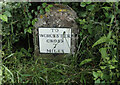
Old Milestone by the B4424, north of Rhydd, Guarlford parish
Metal plate attached to stone post by the B4424, in parish of GUARLFORD (MALVERN HILLS District), North of Rhydd, 200 yds South of drive to Dripshill House, on the verge, on East side of road. Worcester Cross iron plate, erected by the Worcester turnpike trust in the 19th century.
Inscription reads:-
TO
WORCESTER
CROSS
7
MILES
Grade II listed.
List Entry Number: 1302521 https://historicengland.org.uk/listing/the-list/list-entry/1302521
Milestone Society National ID: WO_WOUS07.
Image: © Roadside Relics
Taken: 30 Jun 2021
0.10 miles
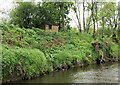
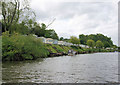
5
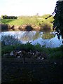
The old Severn Ferry Crossing at the Rhydd
The end of the road east of Malvern - where it meets the River Severn. Once an important port and river crossing.
Image: © Bob Embleton
Taken: 18 Apr 2005
0.18 miles
6
Christmas tree plantation at Portocks End
From the public footpath looking north-east towards the Farmhouse.
Image: © Trevor Rickard
Taken: 10 Dec 2007
0.20 miles
7
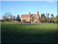
Portocks End
From the public footpath looking northwards to the house, which has impressive chimneys.
Image: © Trevor Rickard
Taken: 10 Dec 2007
0.21 miles
8
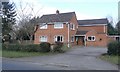
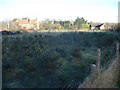
Dripshill Farm
Dripshill Farm viewed from the entrance on the B4211.
Image: © Philip Halling
Taken: 10 Mar 2007
0.21 miles
10
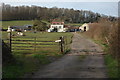
Caravan park, Little Clevelode
Approaching the caravan park from the river Severn.
Image: © Pierre Terre
Taken: 17 May 2009
0.23 miles