IMAGES TAKEN NEAR TO
Rhydd, WORCESTER, WR8 0AD
Introduction
This page details the photographs taken nearby to Rhydd, WR8 0AD by members of the Geograph project.
The Geograph project started in 2005 with the aim of publishing, organising and preserving representative images for every square kilometre of Great Britain, Ireland and the Isle of Man.

There are currently over 7.5m images from over14,400 individuals and you can help contribute to the project by visiting https://www.geograph.org.uk
Image Map
Images are licensed for reuse under creativecommons.org/licenses/by-sa/2.0
Notes
- Clicking on the map will re-center to the selected point.
- The higher the marker number, the further away the image location is from the centre of the postcode.
Image Listing (32 Images Found)
Images are licensed for reuse under creativecommons.org/licenses/by-sa/2.0
Image
Details
Distance
1
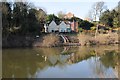
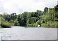
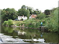
Riverside houses
Riverside houses overlooking the River Severn at the Rhydd.
Image: © Philip Halling
Taken: 8 Feb 2015
0.06 miles
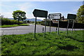
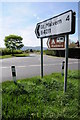
3
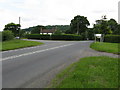
Rhydd junction
All roads to Rhydd meet here.
Image: © Peter Whatley
Taken: 6 Jun 2008
0.06 miles
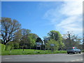
4
Houses at the Rhydd
Houses at the Rhydd viewed from across the River Severn from the Severn Way.
Image: © Philip Halling
Taken: 8 Feb 2015
0.07 miles
5
Road junction at Rhydd
The road junction of the B4211 to Great Malvern with the B4424 which continues north to Powick. From here the B4211 to Great Malvern is locally known as the Guarlford Straight. This picture shows the same junction as photographed by Ben Brooksbank in 1960. Image] The junction is now somewhat more cluttered with signs.
Image: © Philip Halling
Taken: 6 May 2013
0.07 miles
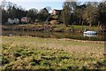
6
River Severn, Rhydd
Approaching Rhydd from the north.
Image: © Pierre Terre
Taken: 17 May 2009
0.07 miles
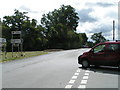
8
Road junction at Rhydd
The road junction of the B4211 to Great Malvern with the B4424 which continues north to Powick. From here the B4211 to Great Malvern is locally known as the Guarlford Straight. This picture shows the same junction as photographed by Ben Brooksbank in 1960. Image]
Image: © Philip Halling
Taken: 6 May 2013
0.07 miles
10
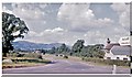
Malvern Hills from The Rhydd, 1960
View westward at the junction of the old A440 (now renumbered B4211) to Great Malvern with the B4424; on the left is Worcester Beacon (1,395 ft), on the right North Hill (1,307 ft).
Image: © Ben Brooksbank
Taken: 19 Aug 1960
0.09 miles