IMAGES TAKEN NEAR TO
Windmill Hill, WORCESTER, WR7 4RW
Introduction
This page details the photographs taken nearby to Windmill Hill, WR7 4RW by members of the Geograph project.
The Geograph project started in 2005 with the aim of publishing, organising and preserving representative images for every square kilometre of Great Britain, Ireland and the Isle of Man.

There are currently over 7.5m images from over14,400 individuals and you can help contribute to the project by visiting https://www.geograph.org.uk
Image Map (Loading...)


Getting Data...Please wait
Leaflet Map data © OpenStreetMap
Images are licensed for reuse under creativecommons.org/licenses/by-sa/2.0
Notes
- Clicking on the map will re-center to the selected point.
- The higher the marker number, the further away the image location is from the centre of the postcode.
Image Listing (25 Images Found)
Images are licensed for reuse under creativecommons.org/licenses/by-sa/2.0
Image
Details
Distance

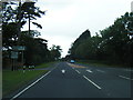
5
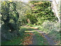
Footpath to Stoulton off Windmill Lane
Image: © Peter Whatley
Taken: 21 Oct 2008
0.13 miles
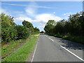
6

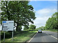
Bus stop on B4084 at Windmill Hill
The road is marked for the turning to the village of Windmill Hill, a short distance north of the main road to Pershore. This stop serves the village.
Image: © David Smith
Taken: 22 May 2013
0.17 miles
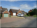
9
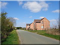
New houses next to a footpath
These are the same houses as Image
Image: © Jeff Gogarty
Taken: 28 Mar 2019
0.19 miles
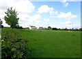
10
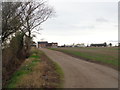
The Old Coalyard with new houses, near Thorndon, Drakes Broughton
Image: © Jeff Gogarty
Taken: 12 Jan 2019
0.19 miles