IMAGES TAKEN NEAR TO
Grafton Flyford, WORCESTER, WR7 4PN
Introduction
This page details the photographs taken nearby to WR7 4PN by members of the Geograph project.
The Geograph project started in 2005 with the aim of publishing, organising and preserving representative images for every square kilometre of Great Britain, Ireland and the Isle of Man.

There are currently over 7.5m images from over14,400 individuals and you can help contribute to the project by visiting https://www.geograph.org.uk
Image Map
Images are licensed for reuse under creativecommons.org/licenses/by-sa/2.0
Notes
- Clicking on the map will re-center to the selected point.
- The higher the marker number, the further away the image location is from the centre of the postcode.
Image Listing (12 Images Found)
Images are licensed for reuse under creativecommons.org/licenses/by-sa/2.0
Image
Details
Distance
2
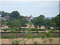
Sheep and Hill Top Farm
Sheep in a field with Hill Top Farm in the background.
Image: © Philip Halling
Taken: 16 Jul 2011
0.07 miles
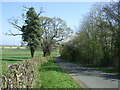
4
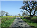
Minor road near Hill Top Farm
Towards Stock Green.
Image: © JThomas
Taken: 8 Apr 2017
0.14 miles
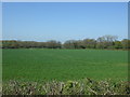
5
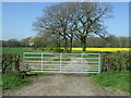
Crop being sprayed off Wychavon Way
Near Hill Top Farm, King's Wood, Grafton Flyford. (Not the farm now known as Hill Court).
Image: © Jeff Gogarty
Taken: 3 Aug 2021
0.19 miles
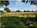
8
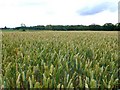
Wheat field
This field of wheat just starting to turn from green to gold was just west of the minor road between Graton Flyford and Stock Green.
Image: © Nigel Mykura
Taken: 18 Jul 2010
0.21 miles
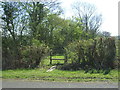
9

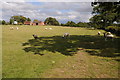
Footpath to Hill Top Farm
Two footpaths cross farmland to the right one of which leads to Hill Top Farm.
Image: © Philip Halling
Taken: 16 Jul 2011
0.22 miles
10
Minor road towards Stock Green
Looking north east.
Image: © JThomas
Taken: 8 Apr 2017
0.24 miles